You are here: Home > Network List > BK - Berkeley Digital Seismograph Network Stations List
> Station ORV Oroville Dam, CA > Earthquake Result Viewer
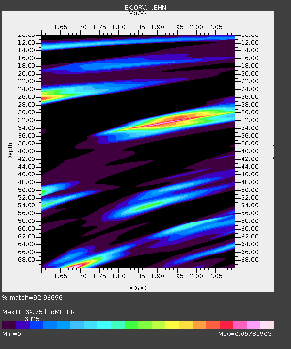
ORV Oroville Dam, CA - Earthquake Result Viewer
| Earthquake location: |
Mariana Islands |
| Earthquake latitude/longitude: |
14.5/147.0 |
| Earthquake time(UTC): |
2004/10/04 (278) 19:20:34 GMT |
| Earthquake Depth: |
7.2 km |
| Earthquake Magnitude: |
5.9 MB, 5.9 MS, 6.0 MW, 5.9 MW |
| Earthquake Catalog/Contributor: |
WHDF/NEIC |
|
| Network: |
BK Berkeley Digital Seismograph Network |
| Station: |
ORV Oroville Dam, CA |
| Lat/Lon: |
39.55 N/121.50 W |
| Elevation: |
335 m |
|
| Distance: |
82.0 deg |
| Az: |
51.295 deg |
| Baz: |
282.189 deg |
| Ray Param: |
0.047174115 |
| Estimated Moho Depth: |
69.75 km |
| Estimated Crust Vp/Vs: |
1.68 |
| Assumed Crust Vp: |
6.597 km/s |
| Estimated Crust Vs: |
3.921 km/s |
| Estimated Crust Poisson's Ratio: |
0.23 |
|
| Radial Match: |
92.96696 % |
| Radial Bump: |
343 |
| Transverse Match: |
85.8737 % |
| Transverse Bump: |
400 |
| SOD ConfigId: |
2459 |
| Insert Time: |
2010-03-05 19:46:22.807 +0000 |
| GWidth: |
2.5 |
| Max Bumps: |
400 |
| Tol: |
0.001 |
|

Signal To Noise
| Channel | StoN | STA | LTA |
| BK:ORV: :BHN:20041004T19:32:24.261006Z | 2.1255724 | 1.0999463E-7 | 5.1748238E-8 |
| BK:ORV: :BHE:20041004T19:32:24.261006Z | 7.0347505 | 3.8584218E-7 | 5.4848023E-8 |
| BK:ORV: :BHZ:20041004T19:32:24.261006Z | 11.66164 | 8.034515E-7 | 6.889695E-8 |
| Arrivals |
| Ps | 7.4 SECOND |
| PpPs | 28 SECOND |
| PsPs/PpSs | 35 SECOND |


