You are here: Home > Network List > N4 - Central and EAstern US Network Stations List
> Station R58B Mineral, VA, USA > Earthquake Result Viewer
R58B Mineral, VA, USA - Earthquake Result Viewer
| Earthquake location: |
San Juan Province, Argentina |
| Earthquake latitude/longitude: |
-31.6/-68.8 |
| Earthquake time(UTC): |
2016/11/20 (325) 20:57:43 GMT |
| Earthquake Depth: |
116 km |
| Earthquake Magnitude: |
6.4 MWP, 6.5 MWB |
| Earthquake Catalog/Contributor: |
NEIC PDE/NEIC COMCAT |
|
| Network: |
N4 Central and EAstern US Network |
| Station: |
R58B Mineral, VA, USA |
| Lat/Lon: |
37.96 N/77.88 W |
| Elevation: |
116 m |
|
| Distance: |
69.8 deg |
| Az: |
352.332 deg |
| Baz: |
171.721 deg |
| Ray Param: |
0.05512691 |
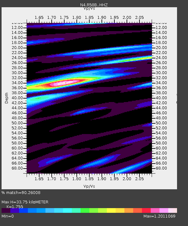
| Estimated Moho Depth: |
33.75 km |
| Estimated Crust Vp/Vs: |
1.75 |
| Assumed Crust Vp: |
6.565 km/s |
| Estimated Crust Vs: |
3.74 km/s |
| Estimated Crust Poisson's Ratio: |
0.26 |
|
| Radial Match: |
90.26008 % |
| Radial Bump: |
376 |
| Transverse Match: |
75.24532 % |
| Transverse Bump: |
400 |
| SOD ConfigId: |
11737051 |
| Insert Time: |
2019-04-26 02:53:50.343 +0000 |
| GWidth: |
2.5 |
| Max Bumps: |
400 |
| Tol: |
0.001 |
|

Signal To Noise
| Channel | StoN | STA | LTA |
| N4:R58B: :HHZ:20161120T21:08:10.800007Z | 18.499084 | 5.881588E-6 | 3.179394E-7 |
| N4:R58B: :HHN:20161120T21:08:10.800007Z | 11.012626 | 2.9162577E-6 | 2.6481038E-7 |
| N4:R58B: :HHE:20161120T21:08:10.800007Z | 1.4010009 | 4.9708905E-7 | 3.5480994E-7 |
| Arrivals |
| Ps | 4.0 SECOND |
| PpPs | 14 SECOND |
| PsPs/PpSs | 18 SECOND |


