You are here: Home > Network List > BK - Berkeley Digital Seismograph Network Stations List
> Station ORV Oroville Dam, CA > Earthquake Result Viewer
ORV Oroville Dam, CA - Earthquake Result Viewer
| Earthquake location: |
Caribbean Sea |
| Earthquake latitude/longitude: |
19.0/-81.4 |
| Earthquake time(UTC): |
2004/12/14 (349) 23:20:13 GMT |
| Earthquake Depth: |
10 km |
| Earthquake Magnitude: |
6.2 MB, 6.7 MS, 6.8 MW, 6.8 MW |
| Earthquake Catalog/Contributor: |
WHDF/NEIC |
|
| Network: |
BK Berkeley Digital Seismograph Network |
| Station: |
ORV Oroville Dam, CA |
| Lat/Lon: |
39.55 N/121.50 W |
| Elevation: |
335 m |
|
| Distance: |
40.1 deg |
| Az: |
309.422 deg |
| Baz: |
108.975 deg |
| Ray Param: |
0.074569404 |
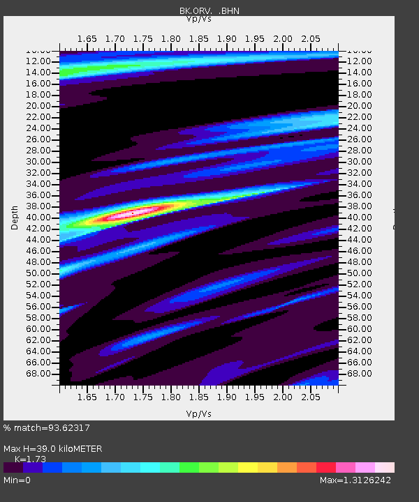
| Estimated Moho Depth: |
39.0 km |
| Estimated Crust Vp/Vs: |
1.73 |
| Assumed Crust Vp: |
6.597 km/s |
| Estimated Crust Vs: |
3.814 km/s |
| Estimated Crust Poisson's Ratio: |
0.25 |
|
| Radial Match: |
93.62317 % |
| Radial Bump: |
398 |
| Transverse Match: |
80.82037 % |
| Transverse Bump: |
400 |
| SOD ConfigId: |
2459 |
| Insert Time: |
2010-03-05 19:46:27.072 +0000 |
| GWidth: |
2.5 |
| Max Bumps: |
400 |
| Tol: |
0.001 |
|

Signal To Noise
| Channel | StoN | STA | LTA |
| BK:ORV: :BHN:20041214T23:27:18.396987Z | 1.9480251 | 7.1918765E-7 | 3.691881E-7 |
| BK:ORV: :BHE:20041214T23:27:18.396987Z | 7.9771876 | 1.8549855E-6 | 2.3253627E-7 |
| BK:ORV: :BHZ:20041214T23:27:18.396987Z | 10.98314 | 3.5026962E-6 | 3.1891577E-7 |
| Arrivals |
| Ps | 4.7 SECOND |
| PpPs | 15 SECOND |
| PsPs/PpSs | 20 SECOND |


