You are here: Home > Network List > N4 - Central and EAstern US Network Stations List
> Station S57A Dark Hallow, Roseland, VA, USA > Earthquake Result Viewer
S57A Dark Hallow, Roseland, VA, USA - Earthquake Result Viewer
| Earthquake location: |
San Juan Province, Argentina |
| Earthquake latitude/longitude: |
-31.6/-68.8 |
| Earthquake time(UTC): |
2016/11/20 (325) 20:57:43 GMT |
| Earthquake Depth: |
116 km |
| Earthquake Magnitude: |
6.4 MWP, 6.5 MWB |
| Earthquake Catalog/Contributor: |
NEIC PDE/NEIC COMCAT |
|
| Network: |
N4 Central and EAstern US Network |
| Station: |
S57A Dark Hallow, Roseland, VA, USA |
| Lat/Lon: |
37.76 N/78.95 W |
| Elevation: |
264 m |
|
| Distance: |
69.7 deg |
| Az: |
351.403 deg |
| Baz: |
170.743 deg |
| Ray Param: |
0.05517348 |
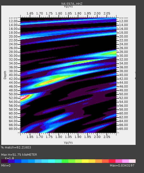
| Estimated Moho Depth: |
51.75 km |
| Estimated Crust Vp/Vs: |
1.60 |
| Assumed Crust Vp: |
6.419 km/s |
| Estimated Crust Vs: |
4.012 km/s |
| Estimated Crust Poisson's Ratio: |
0.18 |
|
| Radial Match: |
92.21803 % |
| Radial Bump: |
304 |
| Transverse Match: |
80.286835 % |
| Transverse Bump: |
400 |
| SOD ConfigId: |
11737051 |
| Insert Time: |
2019-04-26 02:53:55.291 +0000 |
| GWidth: |
2.5 |
| Max Bumps: |
400 |
| Tol: |
0.001 |
|

Signal To Noise
| Channel | StoN | STA | LTA |
| N4:S57A: :HHZ:20161120T21:08:10.370015Z | 16.980204 | 5.3210815E-6 | 3.1336972E-7 |
| N4:S57A: :HHN:20161120T21:08:10.370015Z | 8.387387 | 2.6672153E-6 | 3.1800312E-7 |
| N4:S57A: :HHE:20161120T21:08:10.370015Z | 3.107788 | 5.29073E-7 | 1.7024102E-7 |
| Arrivals |
| Ps | 5.0 SECOND |
| PpPs | 20 SECOND |
| PsPs/PpSs | 25 SECOND |


