You are here: Home > Network List > N4 - Central and EAstern US Network Stations List
> Station U59A Littleton, NC, USA > Earthquake Result Viewer
U59A Littleton, NC, USA - Earthquake Result Viewer
| Earthquake location: |
San Juan Province, Argentina |
| Earthquake latitude/longitude: |
-31.6/-68.8 |
| Earthquake time(UTC): |
2016/11/20 (325) 20:57:43 GMT |
| Earthquake Depth: |
116 km |
| Earthquake Magnitude: |
6.4 MWP, 6.5 MWB |
| Earthquake Catalog/Contributor: |
NEIC PDE/NEIC COMCAT |
|
| Network: |
N4 Central and EAstern US Network |
| Station: |
U59A Littleton, NC, USA |
| Lat/Lon: |
36.35 N/77.79 W |
| Elevation: |
99 m |
|
| Distance: |
68.2 deg |
| Az: |
352.157 deg |
| Baz: |
171.71 deg |
| Ray Param: |
0.056177918 |
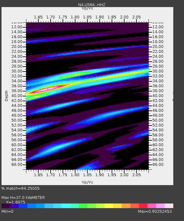
| Estimated Moho Depth: |
37.0 km |
| Estimated Crust Vp/Vs: |
1.69 |
| Assumed Crust Vp: |
6.565 km/s |
| Estimated Crust Vs: |
3.89 km/s |
| Estimated Crust Poisson's Ratio: |
0.23 |
|
| Radial Match: |
94.25005 % |
| Radial Bump: |
380 |
| Transverse Match: |
83.38848 % |
| Transverse Bump: |
324 |
| SOD ConfigId: |
11737051 |
| Insert Time: |
2019-04-26 02:54:02.832 +0000 |
| GWidth: |
2.5 |
| Max Bumps: |
400 |
| Tol: |
0.001 |
|

Signal To Noise
| Channel | StoN | STA | LTA |
| N4:U59A: :HHZ:20161120T21:08:00.930012Z | 18.5535 | 5.3416347E-6 | 2.8790447E-7 |
| N4:U59A: :HHN:20161120T21:08:00.930012Z | 10.720948 | 2.2510455E-6 | 2.0996703E-7 |
| N4:U59A: :HHE:20161120T21:08:00.930012Z | 1.8240038 | 4.868438E-7 | 2.669094E-7 |
| Arrivals |
| Ps | 4.0 SECOND |
| PpPs | 15 SECOND |
| PsPs/PpSs | 19 SECOND |


