You are here: Home > Network List > N4 - Central and EAstern US Network Stations List
> Station V51A Loudon, TN, USA > Earthquake Result Viewer
V51A Loudon, TN, USA - Earthquake Result Viewer
| Earthquake location: |
San Juan Province, Argentina |
| Earthquake latitude/longitude: |
-31.6/-68.8 |
| Earthquake time(UTC): |
2016/11/20 (325) 20:57:43 GMT |
| Earthquake Depth: |
116 km |
| Earthquake Magnitude: |
6.4 MWP, 6.5 MWB |
| Earthquake Catalog/Contributor: |
NEIC PDE/NEIC COMCAT |
|
| Network: |
N4 Central and EAstern US Network |
| Station: |
V51A Loudon, TN, USA |
| Lat/Lon: |
35.80 N/84.35 W |
| Elevation: |
243 m |
|
| Distance: |
68.7 deg |
| Az: |
346.439 deg |
| Baz: |
165.758 deg |
| Ray Param: |
0.055852108 |
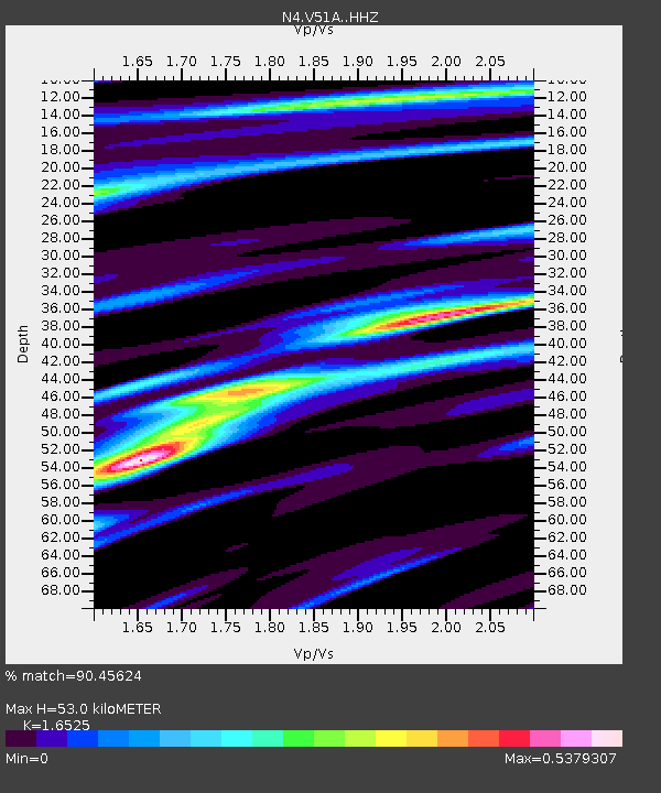
| Estimated Moho Depth: |
53.0 km |
| Estimated Crust Vp/Vs: |
1.65 |
| Assumed Crust Vp: |
6.35 km/s |
| Estimated Crust Vs: |
3.843 km/s |
| Estimated Crust Poisson's Ratio: |
0.21 |
|
| Radial Match: |
90.45624 % |
| Radial Bump: |
382 |
| Transverse Match: |
74.667145 % |
| Transverse Bump: |
400 |
| SOD ConfigId: |
11737051 |
| Insert Time: |
2019-04-26 02:54:04.055 +0000 |
| GWidth: |
2.5 |
| Max Bumps: |
400 |
| Tol: |
0.001 |
|

Signal To Noise
| Channel | StoN | STA | LTA |
| N4:V51A: :HHZ:20161120T21:08:04.039998Z | 18.493118 | 4.5092647E-6 | 2.4383473E-7 |
| N4:V51A: :HHN:20161120T21:08:04.039998Z | 6.4671974 | 1.6401652E-6 | 2.53613E-7 |
| N4:V51A: :HHE:20161120T21:08:04.039998Z | 2.8299234 | 4.6786897E-7 | 1.653292E-7 |
| Arrivals |
| Ps | 5.7 SECOND |
| PpPs | 21 SECOND |
| PsPs/PpSs | 27 SECOND |


