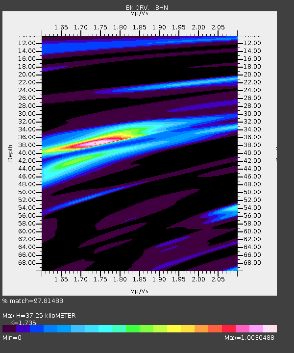
ORV Oroville Dam, CA - Earthquake Result Viewer

Earthquake location: Near West Coast Of Colombia
Earthquake latitude/longitude: 4.7/-77.5
Earthquake time(UTC): 2004/11/15 (320) 09:06:56 GMT
Earthquake Depth: 15 km
Earthquake Magnitude: 6.6 MB, 7.1 MS, 7.2 MW, 7.1 MW
Earthquake Catalog/Contributor: WHDF/NEIC
Network: BK Berkeley Digital Seismograph Network
Station: ORV Oroville Dam, CA
Lat/Lon: 39.55 N/121.50 W
Elevation: 335 m
Distance: 52.7 deg
Az: 317.546 deg
Baz: 119.517 deg
Ray Param: 0.06657716
Estimated Moho Depth: 37.25 km
Estimated Crust Vp/Vs: 1.74
Assumed Crust Vp: 6.597 km/s
Estimated Crust Vs: 3.803 km/s
Estimated Crust Poisson's Ratio: 0.25
Radial Match: 97.81488 %
Radial Bump: 227
Transverse Match: 94.20403 %
Transverse Bump: 400
SOD ConfigId: 2459
Insert Time: 2010-03-05 19:46:35.494 +0000
GWidth: 2.5
Max Bumps: 400
Tol: 0.001

Signal To Noise

ChannelStoNSTALTA
BK:ORV: :BHN:20041115T09:15:39.385012Z11.00649451.3777336E-61.2517461E-7
BK:ORV: :BHE:20041115T09:15:39.385012Z17.9601362.135876E-61.1892315E-7
BK:ORV: :BHZ:20041115T09:15:39.385012Z27.2752254.784355E-61.7541028E-7
Arrivals
Ps4.4 SECOND
PpPs15 SECOND
PsPs/PpSs19 SECOND