You are here: Home > Network List > BK - Berkeley Digital Seismograph Network Stations List
> Station ORV Oroville Dam, CA > Earthquake Result Viewer
ORV Oroville Dam, CA - Earthquake Result Viewer
| Earthquake location: |
Near Coast Of Nicaragua |
| Earthquake latitude/longitude: |
11.4/-86.7 |
| Earthquake time(UTC): |
2004/10/09 (283) 21:26:53 GMT |
| Earthquake Depth: |
35 km |
| Earthquake Magnitude: |
6.0 MB, 7.0 MS, 6.9 MW, 6.8 MW |
| Earthquake Catalog/Contributor: |
WHDF/NEIC |
|
| Network: |
BK Berkeley Digital Seismograph Network |
| Station: |
ORV Oroville Dam, CA |
| Lat/Lon: |
39.55 N/121.50 W |
| Elevation: |
335 m |
|
| Distance: |
41.7 deg |
| Az: |
318.377 deg |
| Baz: |
122.61 deg |
| Ray Param: |
0.073569685 |
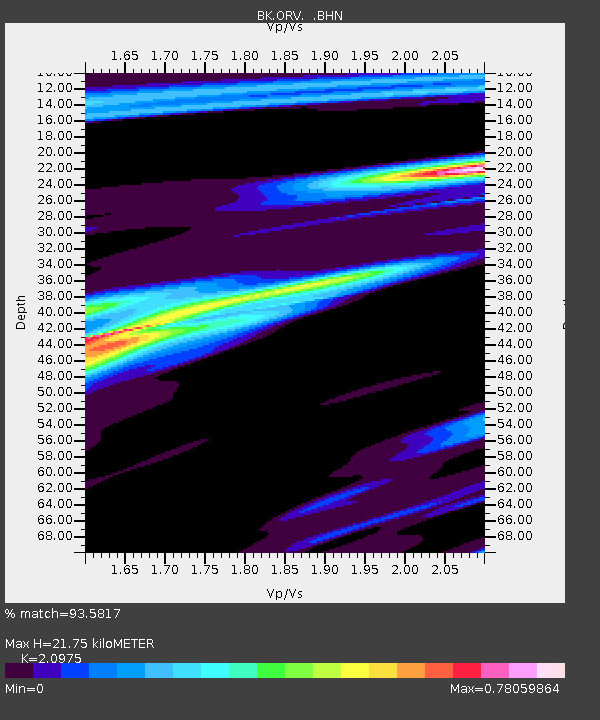
| Estimated Moho Depth: |
21.75 km |
| Estimated Crust Vp/Vs: |
2.10 |
| Assumed Crust Vp: |
6.597 km/s |
| Estimated Crust Vs: |
3.145 km/s |
| Estimated Crust Poisson's Ratio: |
0.35 |
|
| Radial Match: |
93.5817 % |
| Radial Bump: |
289 |
| Transverse Match: |
65.384514 % |
| Transverse Bump: |
400 |
| SOD ConfigId: |
2459 |
| Insert Time: |
2010-03-05 19:46:42.995 +0000 |
| GWidth: |
2.5 |
| Max Bumps: |
400 |
| Tol: |
0.001 |
|

Signal To Noise
| Channel | StoN | STA | LTA |
| BK:ORV: :BHN:20041009T21:34:08.410001Z | 1.723748 | 8.682881E-7 | 5.03721E-7 |
| BK:ORV: :BHE:20041009T21:34:08.410001Z | 3.5695627 | 1.1013749E-6 | 3.0854616E-7 |
| BK:ORV: :BHZ:20041009T21:34:08.410001Z | 3.6926582 | 1.7396329E-6 | 4.711059E-7 |
| Arrivals |
| Ps | 3.8 SECOND |
| PpPs | 9.6 SECOND |
| PsPs/PpSs | 13 SECOND |


