You are here: Home > Network List > NN - Western Great Basin/Eastern Sierra Nevada Stations List
> Station DSP Deep Springs, California w84gm > Earthquake Result Viewer
DSP Deep Springs, California w84gm - Earthquake Result Viewer
| Earthquake location: |
San Juan Province, Argentina |
| Earthquake latitude/longitude: |
-31.6/-68.8 |
| Earthquake time(UTC): |
2016/11/20 (325) 20:57:43 GMT |
| Earthquake Depth: |
116 km |
| Earthquake Magnitude: |
6.4 MWP, 6.5 MWB |
| Earthquake Catalog/Contributor: |
NEIC PDE/NEIC COMCAT |
|
| Network: |
NN Western Great Basin/Eastern Sierra Nevada |
| Station: |
DSP Deep Springs, California w84gm |
| Lat/Lon: |
37.37 N/117.97 W |
| Elevation: |
1692 m |
|
| Distance: |
82.6 deg |
| Az: |
322.539 deg |
| Baz: |
139.375 deg |
| Ray Param: |
0.04650333 |
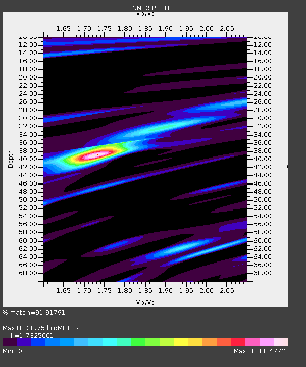
| Estimated Moho Depth: |
38.75 km |
| Estimated Crust Vp/Vs: |
1.73 |
| Assumed Crust Vp: |
6.279 km/s |
| Estimated Crust Vs: |
3.624 km/s |
| Estimated Crust Poisson's Ratio: |
0.25 |
|
| Radial Match: |
91.91791 % |
| Radial Bump: |
400 |
| Transverse Match: |
82.18186 % |
| Transverse Bump: |
400 |
| SOD ConfigId: |
11737051 |
| Insert Time: |
2019-04-26 02:54:36.122 +0000 |
| GWidth: |
2.5 |
| Max Bumps: |
400 |
| Tol: |
0.001 |
|

Signal To Noise
| Channel | StoN | STA | LTA |
| NN:DSP: :HHZ:20161120T21:09:23.258015Z | 21.070803 | 3.1317036E-6 | 1.4862763E-7 |
| NN:DSP: :HHN:20161120T21:09:23.258015Z | 7.2244663 | 8.7009914E-7 | 1.2043785E-7 |
| NN:DSP: :HHE:20161120T21:09:23.258015Z | 2.2938917 | 8.221774E-7 | 3.5842032E-7 |
| Arrivals |
| Ps | 4.6 SECOND |
| PpPs | 16 SECOND |
| PsPs/PpSs | 21 SECOND |


