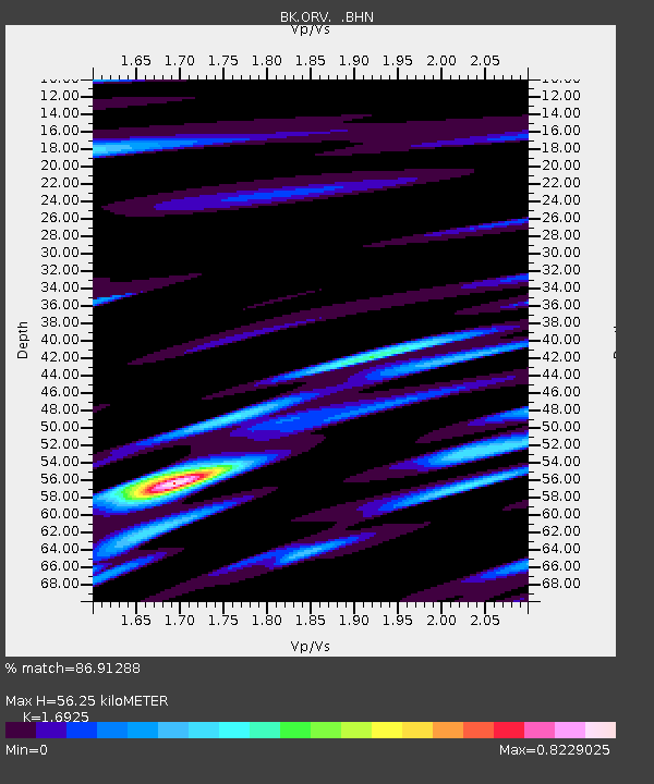
ORV Oroville Dam, CA - Earthquake Result Viewer
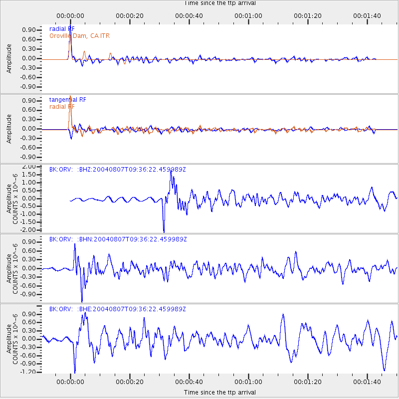
Earthquake location: South Of Aleutian Islands
Earthquake latitude/longitude: 51.8/-166.3
Earthquake time(UTC): 2004/08/07 (220) 09:30:16 GMT
Earthquake Depth: 8.0 km
Earthquake Magnitude: 6.3 MB, 5.4 MS, 6.0 MW, 6.0 MW
Earthquake Catalog/Contributor: WHDF/NEIC
Network: BK Berkeley Digital Seismograph Network
Station: ORV Oroville Dam, CA
Lat/Lon: 39.55 N/121.50 W
Elevation: 335 m
Distance: 33.1 deg
Az: 93.712 deg
Baz: 306.644 deg
Ray Param: 0.07837029
Estimated Moho Depth: 56.25 km
Estimated Crust Vp/Vs: 1.69
Assumed Crust Vp: 6.597 km/s
Estimated Crust Vs: 3.898 km/s
Estimated Crust Poisson's Ratio: 0.23
Radial Match: 86.91288 %
Radial Bump: 400
Transverse Match: 68.840614 %
Transverse Bump: 400
SOD ConfigId: 2459
Insert Time: 2010-03-05 19:46:56.381 +0000
GWidth: 2.5
Max Bumps: 400
Tol: 0.001

Signal To Noise

ChannelStoNSTALTA
BK:ORV: :BHN:20040807T09:36:22.459989Z7.219324.1955408E-75.8115457E-8
BK:ORV: :BHE:20040807T09:36:22.459989Z5.9645245.138021E-78.6143025E-8
BK:ORV: :BHZ:20040807T09:36:22.459989Z9.5657758.86876E-79.271346E-8
Arrivals
Ps6.4 SECOND
PpPs21 SECOND
PsPs/PpSs27 SECOND