You are here: Home > Network List > OK - Oklahoma Seismic Network Stations List
> Station QUOK Quay, Oklahoma > Earthquake Result Viewer
QUOK Quay, Oklahoma - Earthquake Result Viewer
| Earthquake location: |
San Juan Province, Argentina |
| Earthquake latitude/longitude: |
-31.6/-68.8 |
| Earthquake time(UTC): |
2016/11/20 (325) 20:57:43 GMT |
| Earthquake Depth: |
116 km |
| Earthquake Magnitude: |
6.4 MWP, 6.5 MWB |
| Earthquake Catalog/Contributor: |
NEIC PDE/NEIC COMCAT |
|
| Network: |
OK Oklahoma Seismic Network |
| Station: |
QUOK Quay, Oklahoma |
| Lat/Lon: |
36.17 N/96.71 W |
| Elevation: |
296 m |
|
| Distance: |
72.4 deg |
| Az: |
336.556 deg |
| Baz: |
155.205 deg |
| Ray Param: |
0.053419806 |
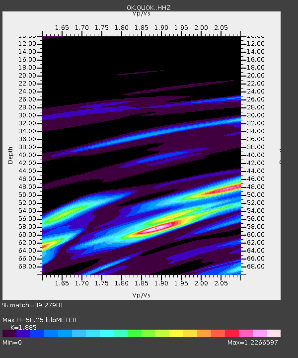
| Estimated Moho Depth: |
58.25 km |
| Estimated Crust Vp/Vs: |
1.88 |
| Assumed Crust Vp: |
6.483 km/s |
| Estimated Crust Vs: |
3.439 km/s |
| Estimated Crust Poisson's Ratio: |
0.30 |
|
| Radial Match: |
89.27981 % |
| Radial Bump: |
400 |
| Transverse Match: |
70.69455 % |
| Transverse Bump: |
400 |
| SOD ConfigId: |
11737051 |
| Insert Time: |
2019-04-26 02:55:31.910 +0000 |
| GWidth: |
2.5 |
| Max Bumps: |
400 |
| Tol: |
0.001 |
|

Signal To Noise
| Channel | StoN | STA | LTA |
| OK:QUOK: :HHZ:20161120T21:08:26.445027Z | 22.364367 | 6.93723E-6 | 3.101912E-7 |
| OK:QUOK: :HHN:20161120T21:08:26.445027Z | 6.1201215 | 3.3141382E-6 | 5.4151513E-7 |
| OK:QUOK: :HHE:20161120T21:08:26.445027Z | 5.2078657 | 2.0034934E-6 | 3.8470526E-7 |
| Arrivals |
| Ps | 8.2 SECOND |
| PpPs | 25 SECOND |
| PsPs/PpSs | 33 SECOND |


