You are here: Home > Network List > US - United States National Seismic Network Stations List
> Station MNTX Cornudas Mountains, Texas, USA > Earthquake Result Viewer
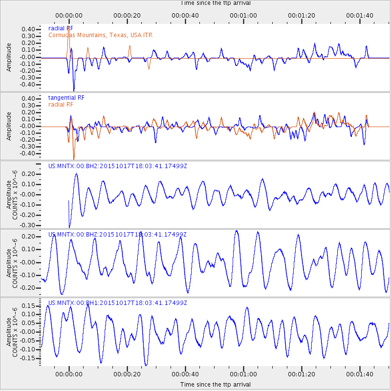
MNTX Cornudas Mountains, Texas, USA - Earthquake Result Viewer
*The percent match for this event was below the threshold and hence no stack was calculated.
| Earthquake location: |
West Chile Rise |
| Earthquake latitude/longitude: |
-42.6/-82.4 |
| Earthquake time(UTC): |
2015/10/17 (290) 17:52:20 GMT |
| Earthquake Depth: |
11 km |
| Earthquake Magnitude: |
5.6 MWW, 5.6 MWB, 5.6 MWC |
| Earthquake Catalog/Contributor: |
NEIC PDE/NEIC COMCAT |
|
| Network: |
US United States National Seismic Network |
| Station: |
MNTX Cornudas Mountains, Texas, USA |
| Lat/Lon: |
31.70 N/105.38 W |
| Elevation: |
404 m |
|
| Distance: |
76.9 deg |
| Az: |
340.062 deg |
| Baz: |
162.827 deg |
| Ray Param: |
$rayparam |
*The percent match for this event was below the threshold and hence was not used in the summary stack. |
|
| Radial Match: |
61.69007 % |
| Radial Bump: |
400 |
| Transverse Match: |
60.49698 % |
| Transverse Bump: |
400 |
| SOD ConfigId: |
1259291 |
| Insert Time: |
2015-10-31 18:12:48.558 +0000 |
| GWidth: |
2.5 |
| Max Bumps: |
400 |
| Tol: |
0.001 |
|
Signal To Noise
| Channel | StoN | STA | LTA |
| US:MNTX:00:BHZ:20151017T18:03:41.17499Z | 0.9838231 | 9.306534E-8 | 9.45956E-8 |
| US:MNTX:00:BH1:20151017T18:03:41.17499Z | 1.0475997 | 9.591008E-8 | 9.155223E-8 |
| US:MNTX:00:BH2:20151017T18:03:41.17499Z | 0.87108886 | 8.678743E-8 | 9.963097E-8 |
| Arrivals |
| Ps | |
| PpPs | |
| PsPs/PpSs | |


