You are here: Home > Network List > PY - PFO Array Stations List
> Station BPH13 Pinon Flat Observatory, CA, USA > Earthquake Result Viewer
BPH13 Pinon Flat Observatory, CA, USA - Earthquake Result Viewer
| Earthquake location: |
San Juan Province, Argentina |
| Earthquake latitude/longitude: |
-31.6/-68.8 |
| Earthquake time(UTC): |
2016/11/20 (325) 20:57:43 GMT |
| Earthquake Depth: |
116 km |
| Earthquake Magnitude: |
6.4 MWP, 6.5 MWB |
| Earthquake Catalog/Contributor: |
NEIC PDE/NEIC COMCAT |
|
| Network: |
PY PFO Array |
| Station: |
BPH13 Pinon Flat Observatory, CA, USA |
| Lat/Lon: |
33.61 N/116.46 W |
| Elevation: |
1300 m |
|
| Distance: |
79.0 deg |
| Az: |
321.035 deg |
| Baz: |
140.008 deg |
| Ray Param: |
0.049017448 |
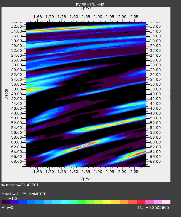
| Estimated Moho Depth: |
61.25 km |
| Estimated Crust Vp/Vs: |
1.84 |
| Assumed Crust Vp: |
6.264 km/s |
| Estimated Crust Vs: |
3.404 km/s |
| Estimated Crust Poisson's Ratio: |
0.29 |
|
| Radial Match: |
91.43701 % |
| Radial Bump: |
370 |
| Transverse Match: |
85.56491 % |
| Transverse Bump: |
400 |
| SOD ConfigId: |
11737051 |
| Insert Time: |
2019-04-26 02:57:12.927 +0000 |
| GWidth: |
2.5 |
| Max Bumps: |
400 |
| Tol: |
0.001 |
|

Signal To Noise
| Channel | StoN | STA | LTA |
| PY:BPH13: :HHZ:20161120T21:09:03.87502Z | 6.137709 | 3.0917718E-6 | 5.037338E-7 |
| PY:BPH13: :HHN:20161120T21:09:03.87502Z | 4.468133 | 8.652448E-7 | 1.9364795E-7 |
| PY:BPH13: :HHE:20161120T21:09:03.87502Z | 3.177784 | 8.878175E-7 | 2.793826E-7 |
| Arrivals |
| Ps | 8.4 SECOND |
| PpPs | 27 SECOND |
| PsPs/PpSs | 35 SECOND |


