You are here: Home > Network List > RV - Regional Alberta Seismic Observatory for Earthquake Studies Network Stations List
> Station WAPA Wapiti River, AB > Earthquake Result Viewer
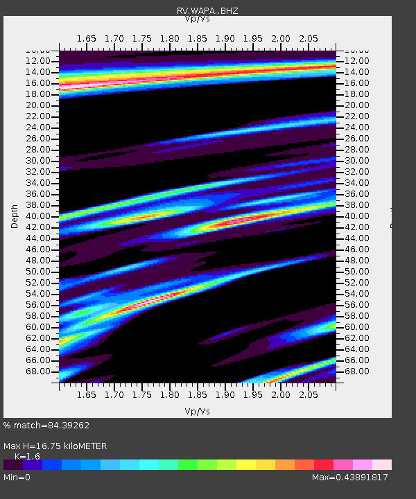
WAPA Wapiti River, AB - Earthquake Result Viewer
| Earthquake location: |
San Juan Province, Argentina |
| Earthquake latitude/longitude: |
-31.6/-68.8 |
| Earthquake time(UTC): |
2016/11/20 (325) 20:57:43 GMT |
| Earthquake Depth: |
116 km |
| Earthquake Magnitude: |
6.4 MWP, 6.5 MWB |
| Earthquake Catalog/Contributor: |
NEIC PDE/NEIC COMCAT |
|
| Network: |
RV Regional Alberta Seismic Observatory for Earthquake Studies Network |
| Station: |
WAPA Wapiti River, AB |
| Lat/Lon: |
55.18 N/119.25 W |
| Elevation: |
784 m |
|
| Distance: |
96.7 deg |
| Az: |
333.544 deg |
| Baz: |
138.507 deg |
| Ray Param: |
0.040345903 |
| Estimated Moho Depth: |
16.75 km |
| Estimated Crust Vp/Vs: |
1.60 |
| Assumed Crust Vp: |
6.161 km/s |
| Estimated Crust Vs: |
3.851 km/s |
| Estimated Crust Poisson's Ratio: |
0.18 |
|
| Radial Match: |
84.39262 % |
| Radial Bump: |
400 |
| Transverse Match: |
62.911926 % |
| Transverse Bump: |
328 |
| SOD ConfigId: |
11737051 |
| Insert Time: |
2019-04-26 02:57:24.798 +0000 |
| GWidth: |
2.5 |
| Max Bumps: |
400 |
| Tol: |
0.001 |
|

Signal To Noise
| Channel | StoN | STA | LTA |
| RV:WAPA: :BHZ:20161120T21:10:29.75002Z | 11.393348 | 2.7926903E-6 | 2.4511587E-7 |
| RV:WAPA: :BHN:20161120T21:10:29.75002Z | 1.5057989 | 4.7341763E-7 | 3.1439632E-7 |
| RV:WAPA: :BHE:20161120T21:10:29.75002Z | 2.646844 | 7.32986E-7 | 2.769283E-7 |
| Arrivals |
| Ps | 1.7 SECOND |
| PpPs | 6.9 SECOND |
| PsPs/PpSs | 8.6 SECOND |


