You are here: Home > Network List > TA - USArray Transportable Network (new EarthScope stations) Stations List
> Station R11A Troy Canyon, Currant, NV, USA > Earthquake Result Viewer
R11A Troy Canyon, Currant, NV, USA - Earthquake Result Viewer

| Earthquake location: |
San Juan Province, Argentina |
| Earthquake latitude/longitude: |
-31.6/-68.8 |
| Earthquake time(UTC): |
2016/11/20 (325) 20:57:43 GMT |
| Earthquake Depth: |
116 km |
| Earthquake Magnitude: |
6.4 MWP, 6.5 MWB |
| Earthquake Catalog/Contributor: |
NEIC PDE/NEIC COMCAT |
|
| Network: |
TA USArray Transportable Network (new EarthScope stations) |
| Station: |
R11A Troy Canyon, Currant, NV, USA |
| Lat/Lon: |
38.35 N/115.59 W |
| Elevation: |
1756 m |
|
| Distance: |
82.2 deg |
| Az: |
324.636 deg |
| Baz: |
141.111 deg |
| Ray Param: |
0.046818025 |
| Estimated Moho Depth: |
21.75 km |
| Estimated Crust Vp/Vs: |
1.60 |
| Assumed Crust Vp: |
6.276 km/s |
| Estimated Crust Vs: |
3.922 km/s |
| Estimated Crust Poisson's Ratio: |
0.18 |
|
| Radial Match: |
92.21712 % |
| Radial Bump: |
352 |
| Transverse Match: |
85.70207 % |
| Transverse Bump: |
400 |
| SOD ConfigId: |
11737051 |
| Insert Time: |
2019-04-26 02:57:59.610 +0000 |
| GWidth: |
2.5 |
| Max Bumps: |
400 |
| Tol: |
0.001 |
|
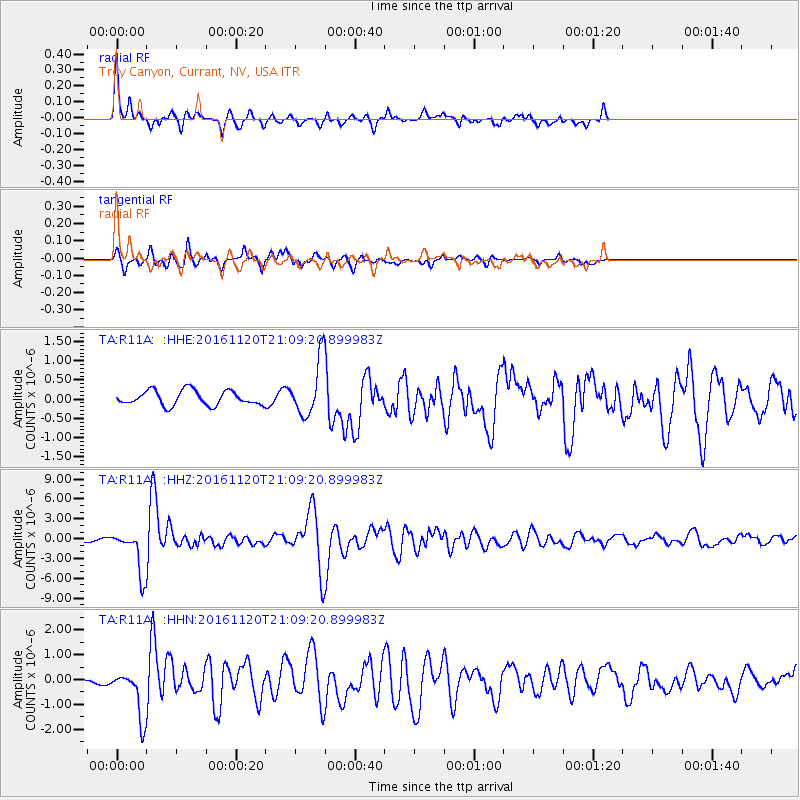
Signal To Noise
| Channel | StoN | STA | LTA |
| TA:R11A: :HHZ:20161120T21:09:20.899983Z | 10.798486 | 3.2767553E-6 | 3.034458E-7 |
| TA:R11A: :HHN:20161120T21:09:20.899983Z | 7.5867124 | 9.699239E-7 | 1.2784508E-7 |
| TA:R11A: :HHE:20161120T21:09:20.899983Z | 3.70477 | 7.065255E-7 | 1.9070697E-7 |
| Arrivals |
| Ps | 2.1 SECOND |
| PpPs | 8.8 SECOND |
| PsPs/PpSs | 11 SECOND |


