You are here: Home > Network List > TA - USArray Transportable Network (new EarthScope stations) Stations List
> Station TPFO Pinon Flats, CA, USA > Earthquake Result Viewer
TPFO Pinon Flats, CA, USA - Earthquake Result Viewer
| Earthquake location: |
San Juan Province, Argentina |
| Earthquake latitude/longitude: |
-31.6/-68.8 |
| Earthquake time(UTC): |
2016/11/20 (325) 20:57:43 GMT |
| Earthquake Depth: |
116 km |
| Earthquake Magnitude: |
6.4 MWP, 6.5 MWB |
| Earthquake Catalog/Contributor: |
NEIC PDE/NEIC COMCAT |
|
| Network: |
TA USArray Transportable Network (new EarthScope stations) |
| Station: |
TPFO Pinon Flats, CA, USA |
| Lat/Lon: |
33.61 N/116.45 W |
| Elevation: |
1275 m |
|
| Distance: |
79.0 deg |
| Az: |
321.037 deg |
| Baz: |
140.012 deg |
| Ray Param: |
0.04902116 |
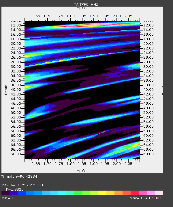
| Estimated Moho Depth: |
11.75 km |
| Estimated Crust Vp/Vs: |
1.88 |
| Assumed Crust Vp: |
6.264 km/s |
| Estimated Crust Vs: |
3.327 km/s |
| Estimated Crust Poisson's Ratio: |
0.30 |
|
| Radial Match: |
90.42834 % |
| Radial Bump: |
394 |
| Transverse Match: |
85.350075 % |
| Transverse Bump: |
400 |
| SOD ConfigId: |
11737051 |
| Insert Time: |
2019-04-26 02:58:05.349 +0000 |
| GWidth: |
2.5 |
| Max Bumps: |
400 |
| Tol: |
0.001 |
|
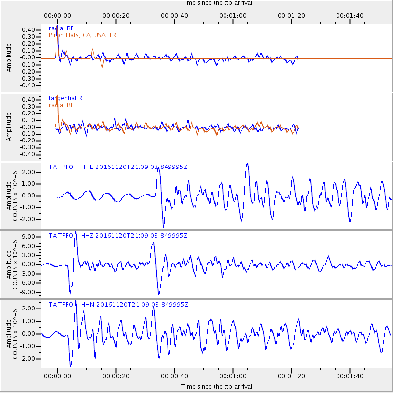
Signal To Noise
| Channel | StoN | STA | LTA |
| TA:TPFO: :HHZ:20161120T21:09:03.849995Z | 6.2655077 | 3.1305922E-6 | 4.9965496E-7 |
| TA:TPFO: :HHN:20161120T21:09:03.849995Z | 4.2020087 | 9.0845845E-7 | 2.1619621E-7 |
| TA:TPFO: :HHE:20161120T21:09:03.849995Z | 3.3931434 | 8.947044E-7 | 2.636801E-7 |
| Arrivals |
| Ps | 1.7 SECOND |
| PpPs | 5.3 SECOND |
| PsPs/PpSs | 7.0 SECOND |


