You are here: Home > Network List > YX16 - Raton Basin UNM Broadband Network Stations List
> Station UNM3 SW Corner of NM Stations > Earthquake Result Viewer
UNM3 SW Corner of NM Stations - Earthquake Result Viewer
| Earthquake location: |
San Juan Province, Argentina |
| Earthquake latitude/longitude: |
-31.6/-68.8 |
| Earthquake time(UTC): |
2016/11/20 (325) 20:57:43 GMT |
| Earthquake Depth: |
116 km |
| Earthquake Magnitude: |
6.4 MWP, 6.5 MWB |
| Earthquake Catalog/Contributor: |
NEIC PDE/NEIC COMCAT |
|
| Network: |
YX Raton Basin UNM Broadband Network |
| Station: |
UNM3 SW Corner of NM Stations |
| Lat/Lon: |
36.84 N/105.04 W |
| Elevation: |
2575 m |
|
| Distance: |
76.1 deg |
| Az: |
330.73 deg |
| Baz: |
148.681 deg |
| Ray Param: |
0.050933667 |
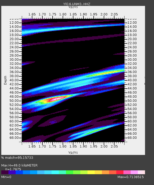
| Estimated Moho Depth: |
49.0 km |
| Estimated Crust Vp/Vs: |
1.77 |
| Assumed Crust Vp: |
6.316 km/s |
| Estimated Crust Vs: |
3.573 km/s |
| Estimated Crust Poisson's Ratio: |
0.26 |
|
| Radial Match: |
95.15733 % |
| Radial Bump: |
362 |
| Transverse Match: |
90.22233 % |
| Transverse Bump: |
400 |
| SOD ConfigId: |
11737051 |
| Insert Time: |
2019-04-26 03:01:31.888 +0000 |
| GWidth: |
2.5 |
| Max Bumps: |
400 |
| Tol: |
0.001 |
|

Signal To Noise
| Channel | StoN | STA | LTA |
| YX:UNM3: :HHZ:20161120T21:08:48.120015Z | 39.780235 | 4.203568E-6 | 1.05669756E-7 |
| YX:UNM3: :HHN:20161120T21:08:48.120015Z | 6.858293 | 1.2574275E-6 | 1.8334408E-7 |
| YX:UNM3: :HHE:20161120T21:08:48.120015Z | 3.350492 | 5.096188E-7 | 1.5210267E-7 |
| Arrivals |
| Ps | 6.1 SECOND |
| PpPs | 21 SECOND |
| PsPs/PpSs | 27 SECOND |


