You are here: Home > Network List > AK - Alaska Regional Network Stations List
> Station CUT Chulitna, AK, USA > Earthquake Result Viewer
CUT Chulitna, AK, USA - Earthquake Result Viewer
| Earthquake location: |
Near East Coast Of Honshu, Japan |
| Earthquake latitude/longitude: |
37.4/141.4 |
| Earthquake time(UTC): |
2016/11/21 (326) 20:59:49 GMT |
| Earthquake Depth: |
11 km |
| Earthquake Magnitude: |
6.9 MWB, 7.3 MI |
| Earthquake Catalog/Contributor: |
NEIC PDE/NEIC COMCAT |
|
| Network: |
AK Alaska Regional Network |
| Station: |
CUT Chulitna, AK, USA |
| Lat/Lon: |
62.41 N/150.26 W |
| Elevation: |
574 m |
|
| Distance: |
47.8 deg |
| Az: |
35.761 deg |
| Baz: |
271.653 deg |
| Ray Param: |
0.06977273 |
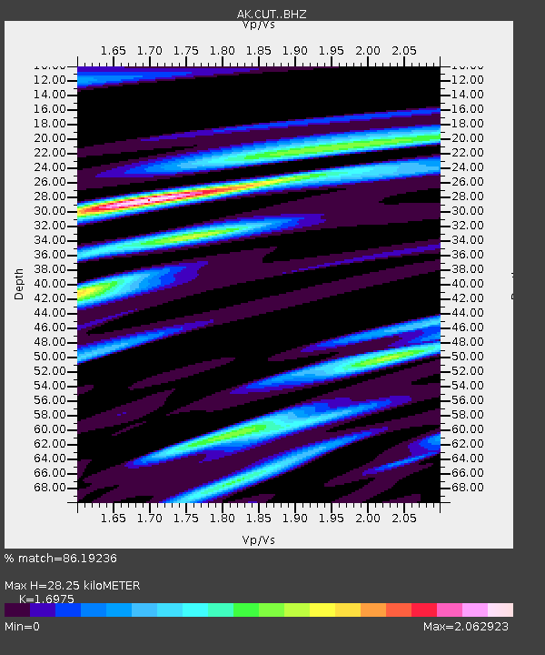
| Estimated Moho Depth: |
28.25 km |
| Estimated Crust Vp/Vs: |
1.70 |
| Assumed Crust Vp: |
6.438 km/s |
| Estimated Crust Vs: |
3.793 km/s |
| Estimated Crust Poisson's Ratio: |
0.23 |
|
| Radial Match: |
86.19236 % |
| Radial Bump: |
400 |
| Transverse Match: |
76.14944 % |
| Transverse Bump: |
400 |
| SOD ConfigId: |
11737051 |
| Insert Time: |
2019-04-26 03:02:50.371 +0000 |
| GWidth: |
2.5 |
| Max Bumps: |
400 |
| Tol: |
0.001 |
|

Signal To Noise
| Channel | StoN | STA | LTA |
| AK:CUT: :BHZ:20161121T21:07:55.119985Z | 5.4023466 | 1.6321422E-6 | 3.021173E-7 |
| AK:CUT: :BHN:20161121T21:07:55.119985Z | 1.0164082 | 1.0321546E-6 | 1.0154922E-6 |
| AK:CUT: :BHE:20161121T21:07:55.119985Z | 1.1059827 | 9.125847E-7 | 8.251347E-7 |
| Arrivals |
| Ps | 3.3 SECOND |
| PpPs | 11 SECOND |
| PsPs/PpSs | 14 SECOND |


