You are here: Home > Network List > AK - Alaska Regional Network Stations List
> Station SKN Skwentna > Earthquake Result Viewer
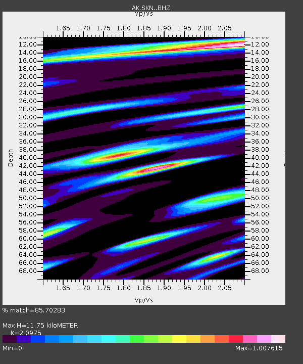
SKN Skwentna - Earthquake Result Viewer
| Earthquake location: |
Near East Coast Of Honshu, Japan |
| Earthquake latitude/longitude: |
37.4/141.4 |
| Earthquake time(UTC): |
2016/11/21 (326) 20:59:49 GMT |
| Earthquake Depth: |
11 km |
| Earthquake Magnitude: |
6.9 MWB, 7.3 MI |
| Earthquake Catalog/Contributor: |
NEIC PDE/NEIC COMCAT |
|
| Network: |
AK Alaska Regional Network |
| Station: |
SKN Skwentna |
| Lat/Lon: |
61.98 N/151.53 W |
| Elevation: |
603 m |
|
| Distance: |
47.2 deg |
| Az: |
36.358 deg |
| Baz: |
270.938 deg |
| Ray Param: |
0.070150875 |
| Estimated Moho Depth: |
11.75 km |
| Estimated Crust Vp/Vs: |
2.10 |
| Assumed Crust Vp: |
6.302 km/s |
| Estimated Crust Vs: |
3.004 km/s |
| Estimated Crust Poisson's Ratio: |
0.35 |
|
| Radial Match: |
85.70283 % |
| Radial Bump: |
400 |
| Transverse Match: |
72.498024 % |
| Transverse Bump: |
400 |
| SOD ConfigId: |
11737051 |
| Insert Time: |
2019-04-26 03:03:20.079 +0000 |
| GWidth: |
2.5 |
| Max Bumps: |
400 |
| Tol: |
0.001 |
|

Signal To Noise
| Channel | StoN | STA | LTA |
| AK:SKN: :BHZ:20161121T21:07:50.588003Z | 3.7913377 | 1.2023504E-6 | 3.171309E-7 |
| AK:SKN: :BHN:20161121T21:07:50.588003Z | 1.8550222 | 5.1702546E-7 | 2.7871658E-7 |
| AK:SKN: :BHE:20161121T21:07:50.588003Z | 1.7734935 | 7.76663E-7 | 4.3792832E-7 |
| Arrivals |
| Ps | 2.2 SECOND |
| PpPs | 5.5 SECOND |
| PsPs/PpSs | 7.6 SECOND |


