You are here: Home > Network List > AU - Australian Seismological Centre Stations List
> Station MUN Mundaring, Western Australia > Earthquake Result Viewer
MUN Mundaring, Western Australia - Earthquake Result Viewer
| Earthquake location: |
Near East Coast Of Honshu, Japan |
| Earthquake latitude/longitude: |
37.4/141.4 |
| Earthquake time(UTC): |
2016/11/21 (326) 20:59:49 GMT |
| Earthquake Depth: |
11 km |
| Earthquake Magnitude: |
6.9 MWB, 7.3 MI |
| Earthquake Catalog/Contributor: |
NEIC PDE/NEIC COMCAT |
|
| Network: |
AU Australian Seismological Centre |
| Station: |
MUN Mundaring, Western Australia |
| Lat/Lon: |
31.98 S/116.21 E |
| Elevation: |
253 m |
|
| Distance: |
72.9 deg |
| Az: |
202.239 deg |
| Baz: |
20.775 deg |
| Ray Param: |
0.0533445 |
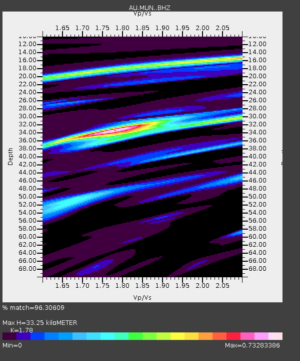
| Estimated Moho Depth: |
33.25 km |
| Estimated Crust Vp/Vs: |
1.78 |
| Assumed Crust Vp: |
6.419 km/s |
| Estimated Crust Vs: |
3.606 km/s |
| Estimated Crust Poisson's Ratio: |
0.27 |
|
| Radial Match: |
96.30609 % |
| Radial Bump: |
258 |
| Transverse Match: |
88.89305 % |
| Transverse Bump: |
368 |
| SOD ConfigId: |
11737051 |
| Insert Time: |
2019-04-26 03:03:45.070 +0000 |
| GWidth: |
2.5 |
| Max Bumps: |
400 |
| Tol: |
0.001 |
|

Signal To Noise
| Channel | StoN | STA | LTA |
| AU:MUN: :BHZ:20161121T21:10:46.768972Z | 4.7835402 | 1.2651863E-6 | 2.6448745E-7 |
| AU:MUN: :BHN:20161121T21:10:46.768972Z | 3.1050007 | 5.017817E-7 | 1.6160438E-7 |
| AU:MUN: :BHE:20161121T21:10:46.768972Z | 1.7075349 | 2.9912604E-7 | 1.7518005E-7 |
| Arrivals |
| Ps | 4.2 SECOND |
| PpPs | 14 SECOND |
| PsPs/PpSs | 18 SECOND |


