You are here: Home > Network List > CI - Caltech Regional Seismic Network Stations List
> Station ARV Arvin, Arvin, CA, USA > Earthquake Result Viewer
ARV Arvin, Arvin, CA, USA - Earthquake Result Viewer

| Earthquake location: |
Near East Coast Of Honshu, Japan |
| Earthquake latitude/longitude: |
37.4/141.4 |
| Earthquake time(UTC): |
2016/11/21 (326) 20:59:49 GMT |
| Earthquake Depth: |
11 km |
| Earthquake Magnitude: |
6.9 MWB, 7.3 MI |
| Earthquake Catalog/Contributor: |
NEIC PDE/NEIC COMCAT |
|
| Network: |
CI Caltech Regional Seismic Network |
| Station: |
ARV Arvin, Arvin, CA, USA |
| Lat/Lon: |
35.13 N/118.83 W |
| Elevation: |
258 m |
|
| Distance: |
76.4 deg |
| Az: |
56.223 deg |
| Baz: |
306.132 deg |
| Ray Param: |
0.05103567 |
| Estimated Moho Depth: |
63.5 km |
| Estimated Crust Vp/Vs: |
1.77 |
| Assumed Crust Vp: |
6.1 km/s |
| Estimated Crust Vs: |
3.446 km/s |
| Estimated Crust Poisson's Ratio: |
0.27 |
|
| Radial Match: |
90.48835 % |
| Radial Bump: |
400 |
| Transverse Match: |
81.652756 % |
| Transverse Bump: |
400 |
| SOD ConfigId: |
11737051 |
| Insert Time: |
2019-04-26 03:05:03.321 +0000 |
| GWidth: |
2.5 |
| Max Bumps: |
400 |
| Tol: |
0.001 |
|
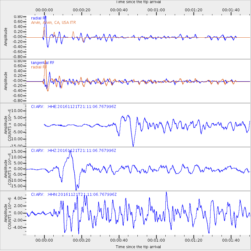
Signal To Noise
| Channel | StoN | STA | LTA |
| CI:ARV: :HHZ:20161121T21:11:06.767996Z | 4.9971356 | 1.2713878E-6 | 2.5442333E-7 |
| CI:ARV: :HHN:20161121T21:11:06.767996Z | 0.85025054 | 3.042243E-7 | 3.5780548E-7 |
| CI:ARV: :HHE:20161121T21:11:06.767996Z | 1.3813915 | 5.968732E-7 | 4.320811E-7 |
| Arrivals |
| Ps | 8.2 SECOND |
| PpPs | 28 SECOND |
| PsPs/PpSs | 36 SECOND |


