You are here: Home > Network List > CN - Canadian National Seismograph Network Stations List
> Station WHY Whitehorse, YT, CA > Earthquake Result Viewer
WHY Whitehorse, YT, CA - Earthquake Result Viewer
| Earthquake location: |
Near East Coast Of Honshu, Japan |
| Earthquake latitude/longitude: |
37.4/141.4 |
| Earthquake time(UTC): |
2016/11/21 (326) 20:59:49 GMT |
| Earthquake Depth: |
11 km |
| Earthquake Magnitude: |
6.9 MWB, 7.3 MI |
| Earthquake Catalog/Contributor: |
NEIC PDE/NEIC COMCAT |
|
| Network: |
CN Canadian National Seismograph Network |
| Station: |
WHY Whitehorse, YT, CA |
| Lat/Lon: |
60.66 N/134.88 W |
| Elevation: |
1273 m |
|
| Distance: |
55.3 deg |
| Az: |
36.542 deg |
| Baz: |
285.659 deg |
| Ray Param: |
0.06487674 |
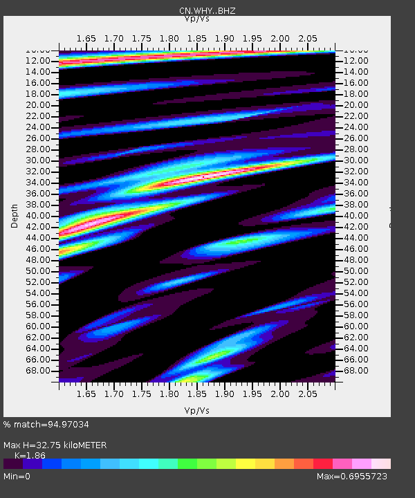
| Estimated Moho Depth: |
32.75 km |
| Estimated Crust Vp/Vs: |
1.86 |
| Assumed Crust Vp: |
6.419 km/s |
| Estimated Crust Vs: |
3.451 km/s |
| Estimated Crust Poisson's Ratio: |
0.30 |
|
| Radial Match: |
94.97034 % |
| Radial Bump: |
331 |
| Transverse Match: |
79.71409 % |
| Transverse Bump: |
400 |
| SOD ConfigId: |
11737051 |
| Insert Time: |
2019-04-26 03:06:24.422 +0000 |
| GWidth: |
2.5 |
| Max Bumps: |
400 |
| Tol: |
0.001 |
|

Signal To Noise
| Channel | StoN | STA | LTA |
| CN:WHY: :BHZ:20161121T21:08:51.37499Z | 4.66794 | 1.2540617E-6 | 2.686542E-7 |
| CN:WHY: :BHN:20161121T21:08:51.37499Z | 1.8372352 | 3.9400743E-7 | 2.144567E-7 |
| CN:WHY: :BHE:20161121T21:08:51.37499Z | 3.320406 | 5.87329E-7 | 1.768847E-7 |
| Arrivals |
| Ps | 4.6 SECOND |
| PpPs | 14 SECOND |
| PsPs/PpSs | 18 SECOND |


