You are here: Home > Network List > N4 - Central and EAstern US Network Stations List
> Station F36B Green Acres Arabians, Milaca, MN, USA > Earthquake Result Viewer
F36B Green Acres Arabians, Milaca, MN, USA - Earthquake Result Viewer
| Earthquake location: |
Near East Coast Of Honshu, Japan |
| Earthquake latitude/longitude: |
37.4/141.4 |
| Earthquake time(UTC): |
2016/11/21 (326) 20:59:49 GMT |
| Earthquake Depth: |
11 km |
| Earthquake Magnitude: |
6.9 MWB, 7.3 MI |
| Earthquake Catalog/Contributor: |
NEIC PDE/NEIC COMCAT |
|
| Network: |
N4 Central and EAstern US Network |
| Station: |
F36B Green Acres Arabians, Milaca, MN, USA |
| Lat/Lon: |
45.86 N/93.52 W |
| Elevation: |
349 m |
|
| Distance: |
83.5 deg |
| Az: |
35.14 deg |
| Baz: |
319.003 deg |
| Ray Param: |
0.046122074 |
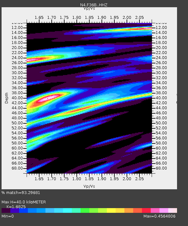
| Estimated Moho Depth: |
40.0 km |
| Estimated Crust Vp/Vs: |
1.68 |
| Assumed Crust Vp: |
6.571 km/s |
| Estimated Crust Vs: |
3.905 km/s |
| Estimated Crust Poisson's Ratio: |
0.23 |
|
| Radial Match: |
93.29681 % |
| Radial Bump: |
272 |
| Transverse Match: |
80.20064 % |
| Transverse Bump: |
400 |
| SOD ConfigId: |
11737051 |
| Insert Time: |
2019-04-26 03:08:34.349 +0000 |
| GWidth: |
2.5 |
| Max Bumps: |
400 |
| Tol: |
0.001 |
|

Signal To Noise
| Channel | StoN | STA | LTA |
| N4:F36B: :HHZ:20161121T21:11:45.330007Z | 5.3298097 | 8.389075E-7 | 1.5739916E-7 |
| N4:F36B: :HHN:20161121T21:11:45.330007Z | 1.6973323 | 2.7629318E-7 | 1.6278085E-7 |
| N4:F36B: :HHE:20161121T21:11:45.330007Z | 2.546048 | 3.200074E-7 | 1.2568789E-7 |
| Arrivals |
| Ps | 4.3 SECOND |
| PpPs | 16 SECOND |
| PsPs/PpSs | 20 SECOND |


