You are here: Home > Network List > N4 - Central and EAstern US Network Stations List
> Station F42A Maple Grove Farm, Niagara, WI, USA > Earthquake Result Viewer
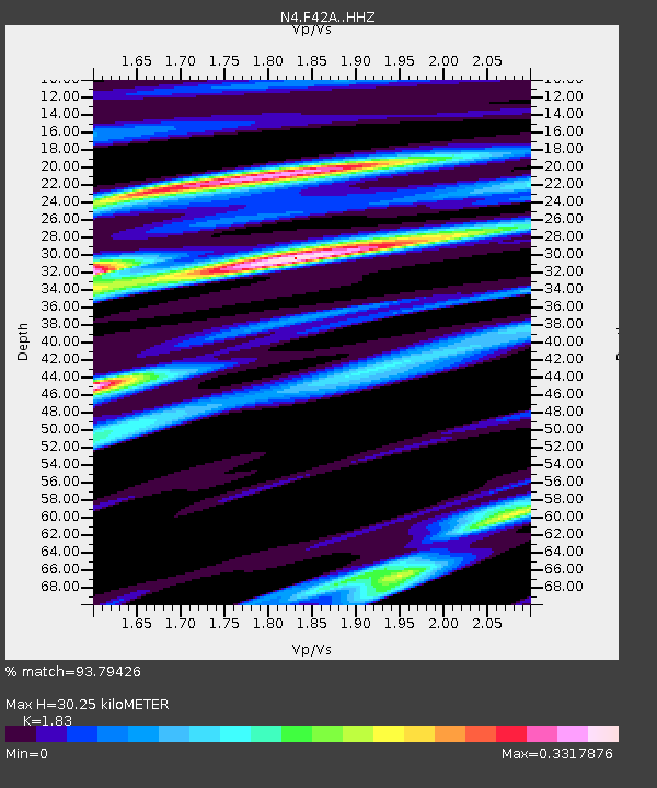
F42A Maple Grove Farm, Niagara, WI, USA - Earthquake Result Viewer
| Earthquake location: |
Near East Coast Of Honshu, Japan |
| Earthquake latitude/longitude: |
37.4/141.4 |
| Earthquake time(UTC): |
2016/11/21 (326) 20:59:49 GMT |
| Earthquake Depth: |
11 km |
| Earthquake Magnitude: |
6.9 MWB, 7.3 MI |
| Earthquake Catalog/Contributor: |
NEIC PDE/NEIC COMCAT |
|
| Network: |
N4 Central and EAstern US Network |
| Station: |
F42A Maple Grove Farm, Niagara, WI, USA |
| Lat/Lon: |
45.76 N/88.13 W |
| Elevation: |
358 m |
|
| Distance: |
86.0 deg |
| Az: |
32.273 deg |
| Baz: |
322.594 deg |
| Ray Param: |
0.044367492 |
| Estimated Moho Depth: |
30.25 km |
| Estimated Crust Vp/Vs: |
1.83 |
| Assumed Crust Vp: |
6.41 km/s |
| Estimated Crust Vs: |
3.503 km/s |
| Estimated Crust Poisson's Ratio: |
0.29 |
|
| Radial Match: |
93.79426 % |
| Radial Bump: |
369 |
| Transverse Match: |
70.877914 % |
| Transverse Bump: |
400 |
| SOD ConfigId: |
11737051 |
| Insert Time: |
2019-04-26 03:08:35.774 +0000 |
| GWidth: |
2.5 |
| Max Bumps: |
400 |
| Tol: |
0.001 |
|

Signal To Noise
| Channel | StoN | STA | LTA |
| N4:F42A: :HHZ:20161121T21:11:57.689993Z | 4.2994947 | 1.1731339E-6 | 2.7285392E-7 |
| N4:F42A: :HHN:20161121T21:11:57.689993Z | 1.3473835 | 4.4383484E-7 | 3.2940497E-7 |
| N4:F42A: :HHE:20161121T21:11:57.689993Z | 1.5342451 | 3.9476265E-7 | 2.573009E-7 |
| Arrivals |
| Ps | 4.0 SECOND |
| PpPs | 13 SECOND |
| PsPs/PpSs | 17 SECOND |


