You are here: Home > Network List > NY - Yukon Northwest Seismic Network(YNSN) Stations List
> Station WTLY Watson Lake, Yukon, CANADA > Earthquake Result Viewer
WTLY Watson Lake, Yukon, CANADA - Earthquake Result Viewer
| Earthquake location: |
Near East Coast Of Honshu, Japan |
| Earthquake latitude/longitude: |
37.4/141.4 |
| Earthquake time(UTC): |
2016/11/21 (326) 20:59:49 GMT |
| Earthquake Depth: |
11 km |
| Earthquake Magnitude: |
6.9 MWB, 7.3 MI |
| Earthquake Catalog/Contributor: |
NEIC PDE/NEIC COMCAT |
|
| Network: |
NY Yukon Northwest Seismic Network(YNSN) |
| Station: |
WTLY Watson Lake, Yukon, CANADA |
| Lat/Lon: |
60.11 N/128.80 W |
| Elevation: |
0.0 m |
|
| Distance: |
58.3 deg |
| Az: |
36.038 deg |
| Baz: |
290.667 deg |
| Ray Param: |
0.06290054 |
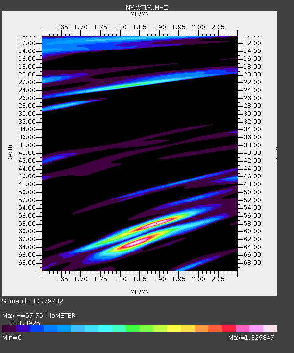
| Estimated Moho Depth: |
57.75 km |
| Estimated Crust Vp/Vs: |
1.89 |
| Assumed Crust Vp: |
6.35 km/s |
| Estimated Crust Vs: |
3.355 km/s |
| Estimated Crust Poisson's Ratio: |
0.31 |
|
| Radial Match: |
83.79782 % |
| Radial Bump: |
277 |
| Transverse Match: |
80.30598 % |
| Transverse Bump: |
400 |
| SOD ConfigId: |
11737051 |
| Insert Time: |
2019-04-26 03:10:13.480 +0000 |
| GWidth: |
2.5 |
| Max Bumps: |
400 |
| Tol: |
0.001 |
|

Signal To Noise
| Channel | StoN | STA | LTA |
| NY:WTLY: :HHZ:20161121T21:09:12.910024Z | 4.060221 | 1.3882159E-6 | 3.4190646E-7 |
| NY:WTLY: :HHN:20161121T21:09:12.910024Z | 1.3087792 | 4.7209704E-7 | 3.6071555E-7 |
| NY:WTLY: :HHE:20161121T21:09:12.910024Z | 1.802063 | 7.776167E-7 | 4.3151474E-7 |
| Arrivals |
| Ps | 8.5 SECOND |
| PpPs | 25 SECOND |
| PsPs/PpSs | 34 SECOND |


