You are here: Home > Network List > OK - Oklahoma Seismic Network Stations List
> Station CROK Carrier, Oklahoma > Earthquake Result Viewer
CROK Carrier, Oklahoma - Earthquake Result Viewer
| Earthquake location: |
Near East Coast Of Honshu, Japan |
| Earthquake latitude/longitude: |
37.4/141.4 |
| Earthquake time(UTC): |
2016/11/21 (326) 20:59:49 GMT |
| Earthquake Depth: |
11 km |
| Earthquake Magnitude: |
6.9 MWB, 7.3 MI |
| Earthquake Catalog/Contributor: |
NEIC PDE/NEIC COMCAT |
|
| Network: |
OK Oklahoma Seismic Network |
| Station: |
CROK Carrier, Oklahoma |
| Lat/Lon: |
36.50 N/97.98 W |
| Elevation: |
403 m |
|
| Distance: |
88.2 deg |
| Az: |
43.928 deg |
| Baz: |
316.702 deg |
| Ray Param: |
0.04275896 |
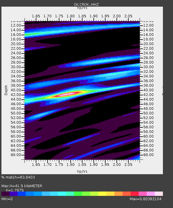
| Estimated Moho Depth: |
41.5 km |
| Estimated Crust Vp/Vs: |
1.79 |
| Assumed Crust Vp: |
6.483 km/s |
| Estimated Crust Vs: |
3.627 km/s |
| Estimated Crust Poisson's Ratio: |
0.27 |
|
| Radial Match: |
93.8403 % |
| Radial Bump: |
349 |
| Transverse Match: |
83.88584 % |
| Transverse Bump: |
400 |
| SOD ConfigId: |
11737051 |
| Insert Time: |
2019-04-26 03:10:17.045 +0000 |
| GWidth: |
2.5 |
| Max Bumps: |
400 |
| Tol: |
0.001 |
|

Signal To Noise
| Channel | StoN | STA | LTA |
| OK:CROK: :HHZ:20161121T21:12:08.393972Z | 4.3360505 | 1.0110568E-6 | 2.3317462E-7 |
| OK:CROK: :HHN:20161121T21:12:08.393972Z | 1.3103595 | 4.3001714E-7 | 3.281673E-7 |
| OK:CROK: :HHE:20161121T21:12:08.393972Z | 1.2220931 | 4.257229E-7 | 3.4835554E-7 |
| Arrivals |
| Ps | 5.2 SECOND |
| PpPs | 17 SECOND |
| PsPs/PpSs | 23 SECOND |


