You are here: Home > Network List > BK - Berkeley Digital Seismograph Network Stations List
> Station PKD Bear Valley Ranch, Parkfield, CA > Earthquake Result Viewer
PKD Bear Valley Ranch, Parkfield, CA - Earthquake Result Viewer
| Earthquake location: |
East Of Kuril Islands |
| Earthquake latitude/longitude: |
46.2/154.5 |
| Earthquake time(UTC): |
2007/01/13 (013) 04:23:21 GMT |
| Earthquake Depth: |
10 km |
| Earthquake Magnitude: |
7.3 MB, 8.2 MS, 8.1 MW, 7.9 MW |
| Earthquake Catalog/Contributor: |
WHDF/NEIC |
|
| Network: |
BK Berkeley Digital Seismograph Network |
| Station: |
PKD Bear Valley Ranch, Parkfield, CA |
| Lat/Lon: |
35.95 N/120.54 W |
| Elevation: |
583 m |
|
| Distance: |
61.9 deg |
| Az: |
66.347 deg |
| Baz: |
308.424 deg |
| Ray Param: |
0.06055874 |
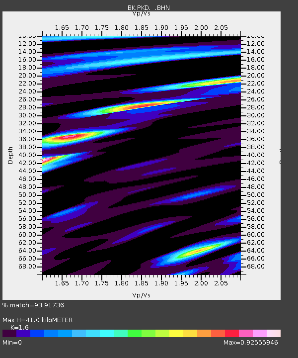
| Estimated Moho Depth: |
41.0 km |
| Estimated Crust Vp/Vs: |
1.60 |
| Assumed Crust Vp: |
6.183 km/s |
| Estimated Crust Vs: |
3.864 km/s |
| Estimated Crust Poisson's Ratio: |
0.18 |
|
| Radial Match: |
93.91736 % |
| Radial Bump: |
400 |
| Transverse Match: |
88.147415 % |
| Transverse Bump: |
400 |
| SOD ConfigId: |
2564 |
| Insert Time: |
2010-03-05 19:51:18.254 +0000 |
| GWidth: |
2.5 |
| Max Bumps: |
400 |
| Tol: |
0.001 |
|

Signal To Noise
| Channel | StoN | STA | LTA |
| BK:PKD: :BHN:20070113T04:33:09.823025Z | 1.9470234 | 6.5638045E-7 | 3.3711996E-7 |
| BK:PKD: :BHE:20070113T04:33:09.823025Z | 4.0600514 | 1.0701854E-6 | 2.6358913E-7 |
| BK:PKD: :BHZ:20070113T04:33:09.823025Z | 5.5203166 | 2.169295E-6 | 3.929657E-7 |
| Arrivals |
| Ps | 4.2 SECOND |
| PpPs | 16 SECOND |
| PsPs/PpSs | 21 SECOND |


