You are here: Home > Network List > RV - Regional Alberta Seismic Observatory for Earthquake Studies Network Stations List
> Station FAIRA Fairview, AB > Earthquake Result Viewer
FAIRA Fairview, AB - Earthquake Result Viewer
| Earthquake location: |
Near East Coast Of Honshu, Japan |
| Earthquake latitude/longitude: |
37.4/141.4 |
| Earthquake time(UTC): |
2016/11/21 (326) 20:59:49 GMT |
| Earthquake Depth: |
11 km |
| Earthquake Magnitude: |
6.9 MWB, 7.3 MI |
| Earthquake Catalog/Contributor: |
NEIC PDE/NEIC COMCAT |
|
| Network: |
RV Regional Alberta Seismic Observatory for Earthquake Studies Network |
| Station: |
FAIRA Fairview, AB |
| Lat/Lon: |
56.11 N/118.86 W |
| Elevation: |
642 m |
|
| Distance: |
64.8 deg |
| Az: |
37.598 deg |
| Baz: |
299.839 deg |
| Ray Param: |
0.05867468 |
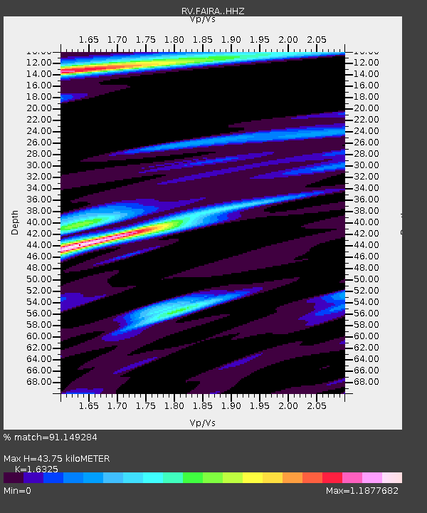
| Estimated Moho Depth: |
43.75 km |
| Estimated Crust Vp/Vs: |
1.63 |
| Assumed Crust Vp: |
6.444 km/s |
| Estimated Crust Vs: |
3.947 km/s |
| Estimated Crust Poisson's Ratio: |
0.20 |
|
| Radial Match: |
91.149284 % |
| Radial Bump: |
317 |
| Transverse Match: |
82.74029 % |
| Transverse Bump: |
400 |
| SOD ConfigId: |
11737051 |
| Insert Time: |
2019-04-26 03:11:14.347 +0000 |
| GWidth: |
2.5 |
| Max Bumps: |
400 |
| Tol: |
0.001 |
|

Signal To Noise
| Channel | StoN | STA | LTA |
| RV:FAIRA: :HHZ:20161121T21:09:56.52001Z | 8.652046 | 1.9708023E-6 | 2.2778454E-7 |
| RV:FAIRA: :HHN:20161121T21:09:56.52001Z | 3.5724185 | 1.3274688E-6 | 3.7158827E-7 |
| RV:FAIRA: :HHE:20161121T21:09:56.52001Z | 1.957458 | 1.1568212E-6 | 5.9098136E-7 |
| Arrivals |
| Ps | 4.5 SECOND |
| PpPs | 17 SECOND |
| PsPs/PpSs | 22 SECOND |


