You are here: Home > Network List > S - Seismographs in Schools Projects Stations List
> Station AUMTC Mt Clear College/Earth Ed, VIC, Australia > Earthquake Result Viewer
AUMTC Mt Clear College/Earth Ed, VIC, Australia - Earthquake Result Viewer
| Earthquake location: |
Near East Coast Of Honshu, Japan |
| Earthquake latitude/longitude: |
37.4/141.4 |
| Earthquake time(UTC): |
2016/11/21 (326) 20:59:49 GMT |
| Earthquake Depth: |
11 km |
| Earthquake Magnitude: |
6.9 MWB, 7.3 MI |
| Earthquake Catalog/Contributor: |
NEIC PDE/NEIC COMCAT |
|
| Network: |
S Seismographs in Schools Projects |
| Station: |
AUMTC Mt Clear College/Earth Ed, VIC, Australia |
| Lat/Lon: |
37.61 S/143.88 E |
| Elevation: |
49 m |
|
| Distance: |
74.7 deg |
| Az: |
177.962 deg |
| Baz: |
357.956 deg |
| Ray Param: |
0.052178703 |
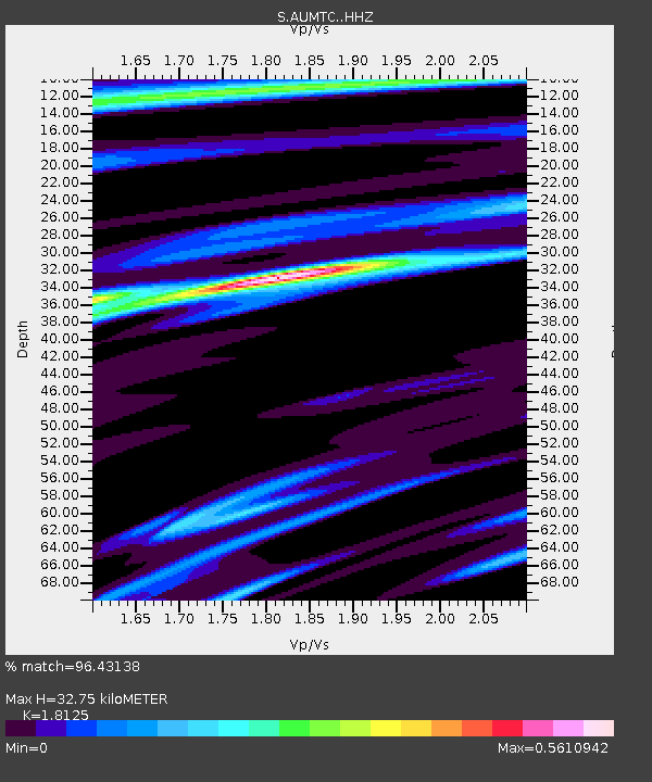
| Estimated Moho Depth: |
32.75 km |
| Estimated Crust Vp/Vs: |
1.81 |
| Assumed Crust Vp: |
6.577 km/s |
| Estimated Crust Vs: |
3.629 km/s |
| Estimated Crust Poisson's Ratio: |
0.28 |
|
| Radial Match: |
96.43138 % |
| Radial Bump: |
268 |
| Transverse Match: |
71.96848 % |
| Transverse Bump: |
400 |
| SOD ConfigId: |
11737051 |
| Insert Time: |
2019-04-26 03:11:28.957 +0000 |
| GWidth: |
2.5 |
| Max Bumps: |
400 |
| Tol: |
0.001 |
|

Signal To Noise
| Channel | StoN | STA | LTA |
| S:AUMTC: :HHZ:20161121T21:10:56.99999Z | 2.671665 | 8.120618E-7 | 3.0395344E-7 |
| S:AUMTC: :HHN:20161121T21:10:56.99999Z | 1.1546115 | 5.190896E-7 | 4.495795E-7 |
| S:AUMTC: :HHE:20161121T21:10:56.99999Z | 0.7412486 | 7.6056523E-7 | 1.0260595E-6 |
| Arrivals |
| Ps | 4.2 SECOND |
| PpPs | 14 SECOND |
| PsPs/PpSs | 18 SECOND |


