You are here: Home > Network List > S - Seismographs in Schools Projects Stations List
> Station AUTKS The King's School, Parramatta, NSW > Earthquake Result Viewer
AUTKS The King's School, Parramatta, NSW - Earthquake Result Viewer
| Earthquake location: |
Near East Coast Of Honshu, Japan |
| Earthquake latitude/longitude: |
37.4/141.4 |
| Earthquake time(UTC): |
2016/11/21 (326) 20:59:49 GMT |
| Earthquake Depth: |
11 km |
| Earthquake Magnitude: |
6.9 MWB, 7.3 MI |
| Earthquake Catalog/Contributor: |
NEIC PDE/NEIC COMCAT |
|
| Network: |
S Seismographs in Schools Projects |
| Station: |
AUTKS The King's School, Parramatta, NSW |
| Lat/Lon: |
33.78 S/151.03 E |
| Elevation: |
95 m |
|
| Distance: |
71.4 deg |
| Az: |
171.552 deg |
| Baz: |
351.924 deg |
| Ray Param: |
0.054365326 |
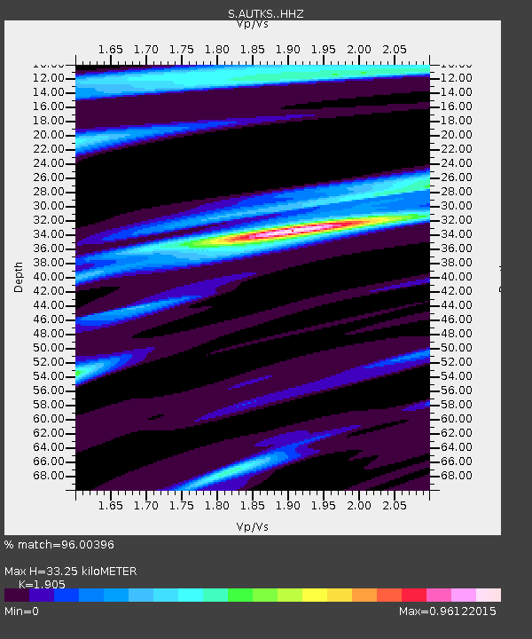
| Estimated Moho Depth: |
33.25 km |
| Estimated Crust Vp/Vs: |
1.90 |
| Assumed Crust Vp: |
6.548 km/s |
| Estimated Crust Vs: |
3.437 km/s |
| Estimated Crust Poisson's Ratio: |
0.31 |
|
| Radial Match: |
96.00396 % |
| Radial Bump: |
298 |
| Transverse Match: |
76.29704 % |
| Transverse Bump: |
400 |
| SOD ConfigId: |
11737051 |
| Insert Time: |
2019-04-26 03:11:35.516 +0000 |
| GWidth: |
2.5 |
| Max Bumps: |
400 |
| Tol: |
0.001 |
|

Signal To Noise
| Channel | StoN | STA | LTA |
| S:AUTKS: :HHZ:20161121T21:10:37.600027Z | 2.552755 | 1.4799738E-6 | 5.7975546E-7 |
| S:AUTKS: :HHN:20161121T21:10:37.600027Z | 1.3994925 | 5.450711E-7 | 3.8947772E-7 |
| S:AUTKS: :HHE:20161121T21:10:37.600027Z | 0.5618104 | 3.143316E-7 | 5.594977E-7 |
| Arrivals |
| Ps | 4.8 SECOND |
| PpPs | 14 SECOND |
| PsPs/PpSs | 19 SECOND |


