You are here: Home > Network List > TA - USArray Transportable Network (new EarthScope stations) Stations List
> Station A36M Sachs Harbour, NT, CAN > Earthquake Result Viewer
A36M Sachs Harbour, NT, CAN - Earthquake Result Viewer
| Earthquake location: |
Near East Coast Of Honshu, Japan |
| Earthquake latitude/longitude: |
37.4/141.4 |
| Earthquake time(UTC): |
2016/11/21 (326) 20:59:49 GMT |
| Earthquake Depth: |
11 km |
| Earthquake Magnitude: |
6.9 MWB, 7.3 MI |
| Earthquake Catalog/Contributor: |
NEIC PDE/NEIC COMCAT |
|
| Network: |
TA USArray Transportable Network (new EarthScope stations) |
| Station: |
A36M Sachs Harbour, NT, CAN |
| Lat/Lon: |
71.99 N/125.25 W |
| Elevation: |
32 m |
|
| Distance: |
55.9 deg |
| Az: |
22.02 deg |
| Baz: |
286.291 deg |
| Ray Param: |
0.064469025 |
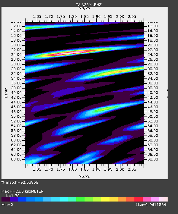
| Estimated Moho Depth: |
23.0 km |
| Estimated Crust Vp/Vs: |
1.79 |
| Assumed Crust Vp: |
6.24 km/s |
| Estimated Crust Vs: |
3.486 km/s |
| Estimated Crust Poisson's Ratio: |
0.27 |
|
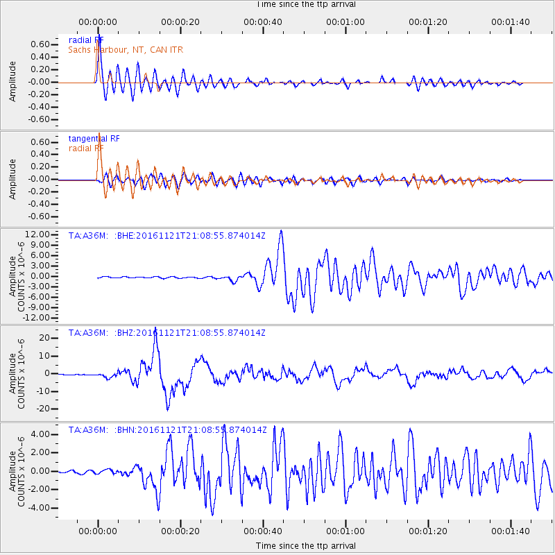
| Radial Match: |
92.03808 % |
| Radial Bump: |
400 |
| Transverse Match: |
87.25206 % |
| Transverse Bump: |
400 |
| SOD ConfigId: |
11737051 |
| Insert Time: |
2019-04-26 03:11:48.187 +0000 |
| GWidth: |
2.5 |
| Max Bumps: |
400 |
| Tol: |
0.001 |
|
Signal To Noise
| Channel | StoN | STA | LTA |
| TA:A36M: :BHZ:20161121T21:08:55.874014Z | 10.159367 | 1.3269552E-6 | 1.3061397E-7 |
| TA:A36M: :BHN:20161121T21:08:55.874014Z | 1.2329788 | 2.2188127E-7 | 1.7995546E-7 |
| TA:A36M: :BHE:20161121T21:08:55.874014Z | 4.2634797 | 8.1079247E-7 | 1.9017152E-7 |
| Arrivals |
| Ps | 3.1 SECOND |
| PpPs | 9.8 SECOND |
| PsPs/PpSs | 13 SECOND |


