You are here: Home > Network List > IW - Intermountain West Stations List
> Station RWWY Rawlins, Wyoming, USA > Earthquake Result Viewer
RWWY Rawlins, Wyoming, USA - Earthquake Result Viewer
| Earthquake location: |
Tonga Islands |
| Earthquake latitude/longitude: |
-16.3/-173.2 |
| Earthquake time(UTC): |
2015/10/18 (291) 16:18:35 GMT |
| Earthquake Depth: |
10 km |
| Earthquake Magnitude: |
5.9 MWB |
| Earthquake Catalog/Contributor: |
NEIC PDE/NEIC COMCAT |
|
| Network: |
IW Intermountain West |
| Station: |
RWWY Rawlins, Wyoming, USA |
| Lat/Lon: |
41.69 N/107.21 W |
| Elevation: |
2402 m |
|
| Distance: |
83.8 deg |
| Az: |
43.485 deg |
| Baz: |
241.95 deg |
| Ray Param: |
0.045954317 |
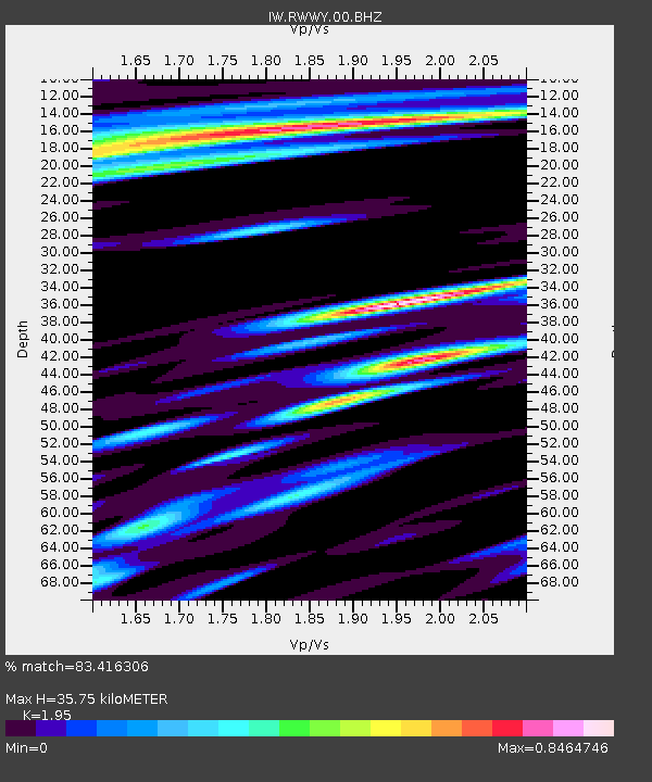
| Estimated Moho Depth: |
35.75 km |
| Estimated Crust Vp/Vs: |
1.95 |
| Assumed Crust Vp: |
6.159 km/s |
| Estimated Crust Vs: |
3.158 km/s |
| Estimated Crust Poisson's Ratio: |
0.32 |
|
| Radial Match: |
83.416306 % |
| Radial Bump: |
400 |
| Transverse Match: |
76.31504 % |
| Transverse Bump: |
345 |
| SOD ConfigId: |
1259291 |
| Insert Time: |
2015-11-01 16:41:00.191 +0000 |
| GWidth: |
2.5 |
| Max Bumps: |
400 |
| Tol: |
0.001 |
|

Signal To Noise
| Channel | StoN | STA | LTA |
| IW:RWWY:00:BHZ:20151018T16:30:32.788972Z | 4.710602 | 6.488991E-7 | 1.377529E-7 |
| IW:RWWY:00:BH1:20151018T16:30:32.788972Z | 1.1795523 | 1.6125453E-7 | 1.3670824E-7 |
| IW:RWWY:00:BH2:20151018T16:30:32.788972Z | 0.9639819 | 1.7410115E-7 | 1.8060624E-7 |
| Arrivals |
| Ps | 5.6 SECOND |
| PpPs | 17 SECOND |
| PsPs/PpSs | 22 SECOND |


