You are here: Home > Network List > TA - USArray Transportable Network (new EarthScope stations) Stations List
> Station O29M Mount Kennedy, YT, CAN > Earthquake Result Viewer
O29M Mount Kennedy, YT, CAN - Earthquake Result Viewer
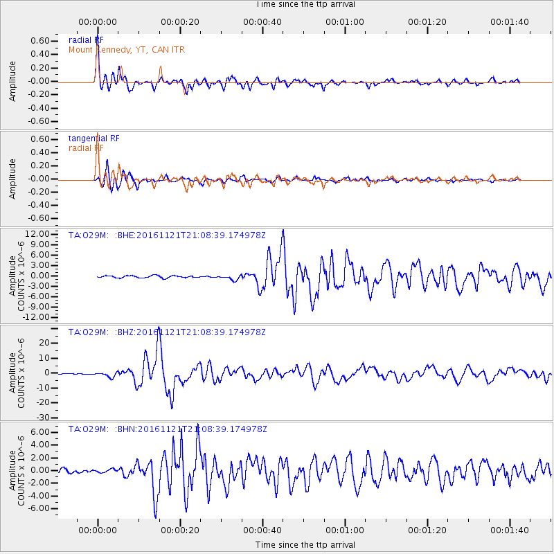
| Earthquake location: |
Near East Coast Of Honshu, Japan |
| Earthquake latitude/longitude: |
37.4/141.4 |
| Earthquake time(UTC): |
2016/11/21 (326) 20:59:49 GMT |
| Earthquake Depth: |
11 km |
| Earthquake Magnitude: |
6.9 MWB, 7.3 MI |
| Earthquake Catalog/Contributor: |
NEIC PDE/NEIC COMCAT |
|
| Network: |
TA USArray Transportable Network (new EarthScope stations) |
| Station: |
O29M Mount Kennedy, YT, CAN |
| Lat/Lon: |
60.30 N/138.58 W |
| Elevation: |
1423 m |
|
| Distance: |
53.6 deg |
| Az: |
37.525 deg |
| Baz: |
283.022 deg |
| Ray Param: |
0.06597305 |
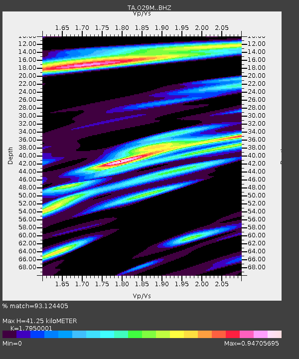
| Estimated Moho Depth: |
41.25 km |
| Estimated Crust Vp/Vs: |
1.80 |
| Assumed Crust Vp: |
6.566 km/s |
| Estimated Crust Vs: |
3.658 km/s |
| Estimated Crust Poisson's Ratio: |
0.27 |
|
| Radial Match: |
93.124405 % |
| Radial Bump: |
400 |
| Transverse Match: |
92.00372 % |
| Transverse Bump: |
400 |
| SOD ConfigId: |
11737051 |
| Insert Time: |
2019-04-26 03:12:52.070 +0000 |
| GWidth: |
2.5 |
| Max Bumps: |
400 |
| Tol: |
0.001 |
|
Signal To Noise
| Channel | StoN | STA | LTA |
| TA:O29M: :BHZ:20161121T21:08:39.174978Z | 8.930606 | 1.6177028E-6 | 1.8114144E-7 |
| TA:O29M: :BHN:20161121T21:08:39.174978Z | 1.1142179 | 2.8067626E-7 | 2.519043E-7 |
| TA:O29M: :BHE:20161121T21:08:39.174978Z | 2.2522116 | 7.038341E-7 | 3.12508E-7 |
| Arrivals |
| Ps | 5.3 SECOND |
| PpPs | 17 SECOND |
| PsPs/PpSs | 22 SECOND |


