You are here: Home > Network List > TA - USArray Transportable Network (new EarthScope stations) Stations List
> Station O48B Farmland, IN, USA > Earthquake Result Viewer
O48B Farmland, IN, USA - Earthquake Result Viewer
| Earthquake location: |
Near East Coast Of Honshu, Japan |
| Earthquake latitude/longitude: |
37.4/141.4 |
| Earthquake time(UTC): |
2016/11/21 (326) 20:59:49 GMT |
| Earthquake Depth: |
11 km |
| Earthquake Magnitude: |
6.9 MWB, 7.3 MI |
| Earthquake Catalog/Contributor: |
NEIC PDE/NEIC COMCAT |
|
| Network: |
TA USArray Transportable Network (new EarthScope stations) |
| Station: |
O48B Farmland, IN, USA |
| Lat/Lon: |
40.26 N/85.16 W |
| Elevation: |
300 m |
|
| Distance: |
91.7 deg |
| Az: |
33.773 deg |
| Baz: |
324.652 deg |
| Ray Param: |
0.041567583 |
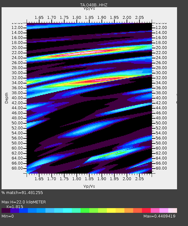
| Estimated Moho Depth: |
22.0 km |
| Estimated Crust Vp/Vs: |
1.82 |
| Assumed Crust Vp: |
6.498 km/s |
| Estimated Crust Vs: |
3.58 km/s |
| Estimated Crust Poisson's Ratio: |
0.28 |
|
| Radial Match: |
91.481255 % |
| Radial Bump: |
400 |
| Transverse Match: |
72.33739 % |
| Transverse Bump: |
400 |
| SOD ConfigId: |
11737051 |
| Insert Time: |
2019-04-26 03:12:54.520 +0000 |
| GWidth: |
2.5 |
| Max Bumps: |
400 |
| Tol: |
0.001 |
|

Signal To Noise
| Channel | StoN | STA | LTA |
| TA:O48B: :HHZ:20161121T21:12:24.720022Z | 3.1140423 | 7.222913E-7 | 2.3194653E-7 |
| TA:O48B: :HHN:20161121T21:12:24.720022Z | 0.99771774 | 2.5662916E-7 | 2.5721621E-7 |
| TA:O48B: :HHE:20161121T21:12:24.720022Z | 1.5472678 | 3.7407392E-7 | 2.4176416E-7 |
| Arrivals |
| Ps | 2.8 SECOND |
| PpPs | 9.3 SECOND |
| PsPs/PpSs | 12 SECOND |


