You are here: Home > Network List > TA - USArray Transportable Network (new EarthScope stations) Stations List
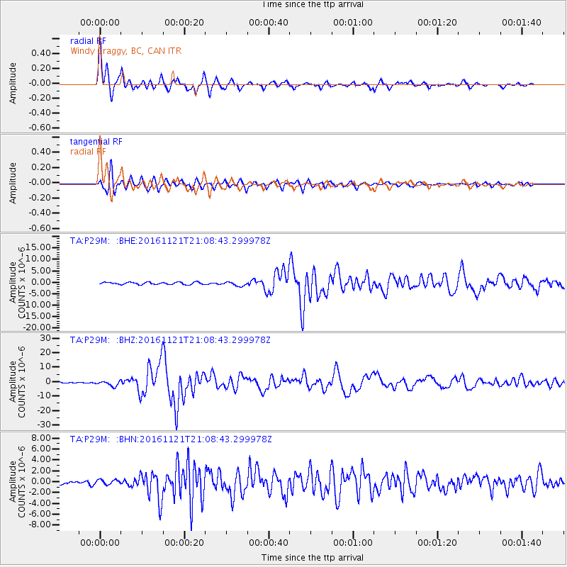
> Station P29M Windy Craggy, BC, CAN > Earthquake Result Viewer
P29M Windy Craggy, BC, CAN - Earthquake Result Viewer
| Earthquake location: |
Near East Coast Of Honshu, Japan |
| Earthquake latitude/longitude: |
37.4/141.4 |
| Earthquake time(UTC): |
2016/11/21 (326) 20:59:49 GMT |
| Earthquake Depth: |
11 km |
| Earthquake Magnitude: |
6.9 MWB, 7.3 MI |
| Earthquake Catalog/Contributor: |
NEIC PDE/NEIC COMCAT |
|
| Network: |
TA USArray Transportable Network (new EarthScope stations) |
| Station: |
P29M Windy Craggy, BC, CAN |
| Lat/Lon: |
59.63 N/137.74 W |
| Elevation: |
679 m |
|
| Distance: |
54.2 deg |
| Az: |
38.213 deg |
| Baz: |
284.151 deg |
| Ray Param: |
0.06559956 |
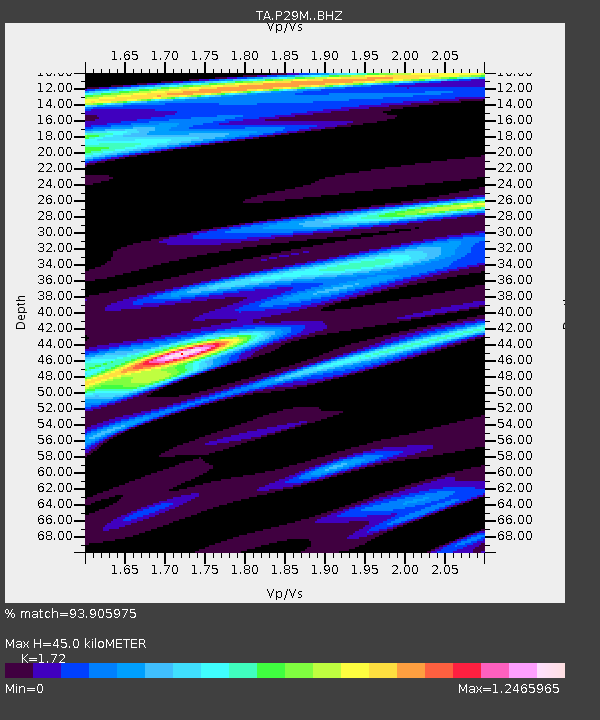
| Estimated Moho Depth: |
45.0 km |
| Estimated Crust Vp/Vs: |
1.72 |
| Assumed Crust Vp: |
6.566 km/s |
| Estimated Crust Vs: |
3.818 km/s |
| Estimated Crust Poisson's Ratio: |
0.24 |
|
| Radial Match: |
93.905975 % |
| Radial Bump: |
322 |
| Transverse Match: |
82.462006 % |
| Transverse Bump: |
400 |
| SOD ConfigId: |
11737051 |
| Insert Time: |
2019-04-26 03:12:57.543 +0000 |
| GWidth: |
2.5 |
| Max Bumps: |
400 |
| Tol: |
0.001 |
|
Signal To Noise
| Channel | StoN | STA | LTA |
| TA:P29M: :BHZ:20161121T21:08:43.299978Z | 4.546522 | 1.7691386E-6 | 3.8911912E-7 |
| TA:P29M: :BHN:20161121T21:08:43.299978Z | 1.1280938 | 4.122804E-7 | 3.654664E-7 |
| TA:P29M: :BHE:20161121T21:08:43.299978Z | 1.9418212 | 9.2491376E-7 | 4.7631252E-7 |
| Arrivals |
| Ps | 5.2 SECOND |
| PpPs | 18 SECOND |
| PsPs/PpSs | 23 SECOND |


