You are here: Home > Network List > TA - USArray Transportable Network (new EarthScope stations) Stations List
> Station S22A 4UR Ranch, Creede, CO, USA > Earthquake Result Viewer
S22A 4UR Ranch, Creede, CO, USA - Earthquake Result Viewer
| Earthquake location: |
Near East Coast Of Honshu, Japan |
| Earthquake latitude/longitude: |
37.4/141.4 |
| Earthquake time(UTC): |
2016/11/21 (326) 20:59:49 GMT |
| Earthquake Depth: |
11 km |
| Earthquake Magnitude: |
6.9 MWB, 7.3 MI |
| Earthquake Catalog/Contributor: |
NEIC PDE/NEIC COMCAT |
|
| Network: |
TA USArray Transportable Network (new EarthScope stations) |
| Station: |
S22A 4UR Ranch, Creede, CO, USA |
| Lat/Lon: |
37.75 N/106.83 W |
| Elevation: |
2626 m |
|
| Distance: |
82.3 deg |
| Az: |
47.982 deg |
| Baz: |
311.716 deg |
| Ray Param: |
0.046999656 |
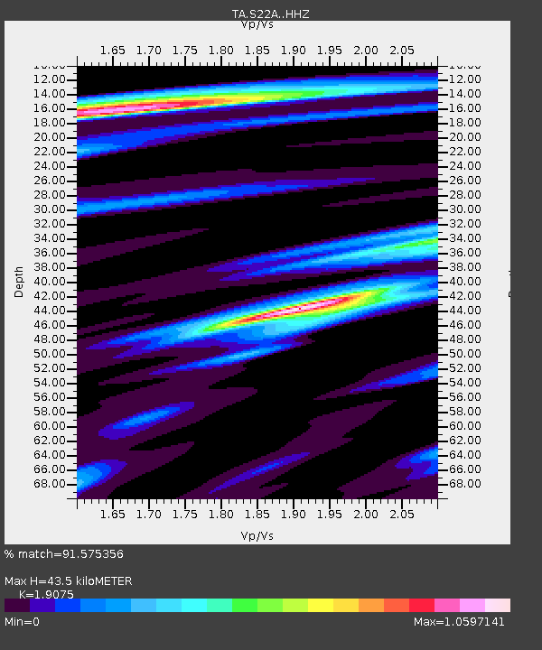
| Estimated Moho Depth: |
43.5 km |
| Estimated Crust Vp/Vs: |
1.91 |
| Assumed Crust Vp: |
6.159 km/s |
| Estimated Crust Vs: |
3.229 km/s |
| Estimated Crust Poisson's Ratio: |
0.31 |
|
| Radial Match: |
91.575356 % |
| Radial Bump: |
400 |
| Transverse Match: |
86.19343 % |
| Transverse Bump: |
400 |
| SOD ConfigId: |
11737051 |
| Insert Time: |
2019-04-26 03:13:10.431 +0000 |
| GWidth: |
2.5 |
| Max Bumps: |
400 |
| Tol: |
0.001 |
|

Signal To Noise
| Channel | StoN | STA | LTA |
| TA:S22A: :HHZ:20161121T21:11:38.850027Z | 6.1275 | 1.0934386E-6 | 1.7844775E-7 |
| TA:S22A: :HHN:20161121T21:11:38.850027Z | 3.104395 | 2.8825497E-7 | 9.285384E-8 |
| TA:S22A: :HHE:20161121T21:11:38.850027Z | 1.3007089 | 2.980027E-7 | 2.2910793E-7 |
| Arrivals |
| Ps | 6.6 SECOND |
| PpPs | 20 SECOND |
| PsPs/PpSs | 27 SECOND |


