You are here: Home > Network List > TD - TransAlta Monitoring Network Stations List
> Station TD009 Z > Earthquake Result Viewer
TD009 Z - Earthquake Result Viewer
| Earthquake location: |
Near East Coast Of Honshu, Japan |
| Earthquake latitude/longitude: |
37.4/141.4 |
| Earthquake time(UTC): |
2016/11/21 (326) 20:59:49 GMT |
| Earthquake Depth: |
11 km |
| Earthquake Magnitude: |
6.9 MWB, 7.3 MI |
| Earthquake Catalog/Contributor: |
NEIC PDE/NEIC COMCAT |
|
| Network: |
TD TransAlta Monitoring Network |
| Station: |
TD009 Z |
| Lat/Lon: |
52.32 N/116.32 W |
| Elevation: |
1335 m |
|
| Distance: |
68.1 deg |
| Az: |
40.283 deg |
| Baz: |
302.97 deg |
| Ray Param: |
0.056540206 |
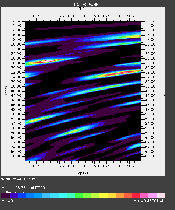
| Estimated Moho Depth: |
26.75 km |
| Estimated Crust Vp/Vs: |
1.70 |
| Assumed Crust Vp: |
6.142 km/s |
| Estimated Crust Vs: |
3.608 km/s |
| Estimated Crust Poisson's Ratio: |
0.24 |
|
| Radial Match: |
89.16951 % |
| Radial Bump: |
400 |
| Transverse Match: |
84.43989 % |
| Transverse Bump: |
400 |
| SOD ConfigId: |
11737051 |
| Insert Time: |
2019-04-26 03:13:23.801 +0000 |
| GWidth: |
2.5 |
| Max Bumps: |
400 |
| Tol: |
0.001 |
|

Signal To Noise
| Channel | StoN | STA | LTA |
| TD:TD009: :HHZ:20161121T21:10:17.28002Z | 3.965601 | 9.054333E-7 | 2.2832184E-7 |
| TD:TD009: :HH1:20161121T21:10:17.28002Z | 0.7989196 | 1.3400147E-7 | 1.6772833E-7 |
| TD:TD009: :HH2:20161121T21:10:17.28002Z | 2.729308 | 2.9129603E-7 | 1.067289E-7 |
| Arrivals |
| Ps | 3.2 SECOND |
| PpPs | 11 SECOND |
| PsPs/PpSs | 15 SECOND |


