You are here: Home > Network List > UW - Pacific Northwest Regional Seismic Network Stations List
> Station DDRF Dider Farm, Eltopia, WA, USA > Earthquake Result Viewer
DDRF Dider Farm, Eltopia, WA, USA - Earthquake Result Viewer
| Earthquake location: |
Near East Coast Of Honshu, Japan |
| Earthquake latitude/longitude: |
37.4/141.4 |
| Earthquake time(UTC): |
2016/11/21 (326) 20:59:49 GMT |
| Earthquake Depth: |
11 km |
| Earthquake Magnitude: |
6.9 MWB, 7.3 MI |
| Earthquake Catalog/Contributor: |
NEIC PDE/NEIC COMCAT |
|
| Network: |
UW Pacific Northwest Regional Seismic Network |
| Station: |
DDRF Dider Farm, Eltopia, WA, USA |
| Lat/Lon: |
46.49 N/119.06 W |
| Elevation: |
233 m |
|
| Distance: |
69.8 deg |
| Az: |
46.568 deg |
| Baz: |
303.159 deg |
| Ray Param: |
0.05543114 |
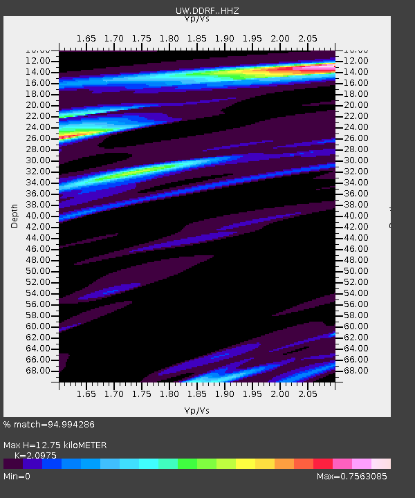
| Estimated Moho Depth: |
12.75 km |
| Estimated Crust Vp/Vs: |
2.10 |
| Assumed Crust Vp: |
6.419 km/s |
| Estimated Crust Vs: |
3.06 km/s |
| Estimated Crust Poisson's Ratio: |
0.35 |
|
| Radial Match: |
94.994286 % |
| Radial Bump: |
367 |
| Transverse Match: |
83.59625 % |
| Transverse Bump: |
400 |
| SOD ConfigId: |
11737051 |
| Insert Time: |
2019-04-26 03:14:04.177 +0000 |
| GWidth: |
2.5 |
| Max Bumps: |
400 |
| Tol: |
0.001 |
|

Signal To Noise
| Channel | StoN | STA | LTA |
| UW:DDRF: :HHZ:20161121T21:10:27.738027Z | 3.6151288 | 1.0832778E-6 | 2.9965122E-7 |
| UW:DDRF: :HHN:20161121T21:10:27.738027Z | 1.2148643 | 2.3909791E-7 | 1.9681039E-7 |
| UW:DDRF: :HHE:20161121T21:10:27.738027Z | 1.912257 | 4.3168836E-7 | 2.2574808E-7 |
| Arrivals |
| Ps | 2.2 SECOND |
| PpPs | 6.0 SECOND |
| PsPs/PpSs | 8.2 SECOND |


