You are here: Home > Network List > UW - Pacific Northwest Regional Seismic Network Stations List
> Station LEBA Lebam, WA, USA > Earthquake Result Viewer
LEBA Lebam, WA, USA - Earthquake Result Viewer
| Earthquake location: |
Near East Coast Of Honshu, Japan |
| Earthquake latitude/longitude: |
37.4/141.4 |
| Earthquake time(UTC): |
2016/11/21 (326) 20:59:49 GMT |
| Earthquake Depth: |
11 km |
| Earthquake Magnitude: |
6.9 MWB, 7.3 MI |
| Earthquake Catalog/Contributor: |
NEIC PDE/NEIC COMCAT |
|
| Network: |
UW Pacific Northwest Regional Seismic Network |
| Station: |
LEBA Lebam, WA, USA |
| Lat/Lon: |
46.55 N/123.56 W |
| Elevation: |
73 m |
|
| Distance: |
67.1 deg |
| Az: |
48.282 deg |
| Baz: |
300.531 deg |
| Ray Param: |
0.057181783 |
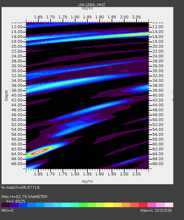
| Estimated Moho Depth: |
62.75 km |
| Estimated Crust Vp/Vs: |
1.65 |
| Assumed Crust Vp: |
6.566 km/s |
| Estimated Crust Vs: |
3.973 km/s |
| Estimated Crust Poisson's Ratio: |
0.21 |
|
| Radial Match: |
89.97716 % |
| Radial Bump: |
400 |
| Transverse Match: |
81.438675 % |
| Transverse Bump: |
400 |
| SOD ConfigId: |
11737051 |
| Insert Time: |
2019-04-26 03:14:11.027 +0000 |
| GWidth: |
2.5 |
| Max Bumps: |
400 |
| Tol: |
0.001 |
|

Signal To Noise
| Channel | StoN | STA | LTA |
| UW:LEBA: :HHZ:20161121T21:10:11.077993Z | 2.329093 | 1.3250848E-6 | 5.689274E-7 |
| UW:LEBA: :HHN:20161121T21:10:11.077993Z | 0.71608776 | 4.56117E-7 | 6.369568E-7 |
| UW:LEBA: :HHE:20161121T21:10:11.077993Z | 0.9191311 | 6.146235E-7 | 6.687006E-7 |
| Arrivals |
| Ps | 6.5 SECOND |
| PpPs | 24 SECOND |
| PsPs/PpSs | 31 SECOND |


