You are here: Home > Network List > UW - Pacific Northwest Regional Seismic Network Stations List
> Station RATT Rattlesnake Lake, WA > Earthquake Result Viewer
RATT Rattlesnake Lake, WA - Earthquake Result Viewer
| Earthquake location: |
Near East Coast Of Honshu, Japan |
| Earthquake latitude/longitude: |
37.4/141.4 |
| Earthquake time(UTC): |
2016/11/21 (326) 20:59:49 GMT |
| Earthquake Depth: |
11 km |
| Earthquake Magnitude: |
6.9 MWB, 7.3 MI |
| Earthquake Catalog/Contributor: |
NEIC PDE/NEIC COMCAT |
|
| Network: |
UW Pacific Northwest Regional Seismic Network |
| Station: |
RATT Rattlesnake Lake, WA |
| Lat/Lon: |
47.43 N/121.80 W |
| Elevation: |
440 m |
|
| Distance: |
67.7 deg |
| Az: |
46.794 deg |
| Baz: |
301.242 deg |
| Ray Param: |
0.056801923 |
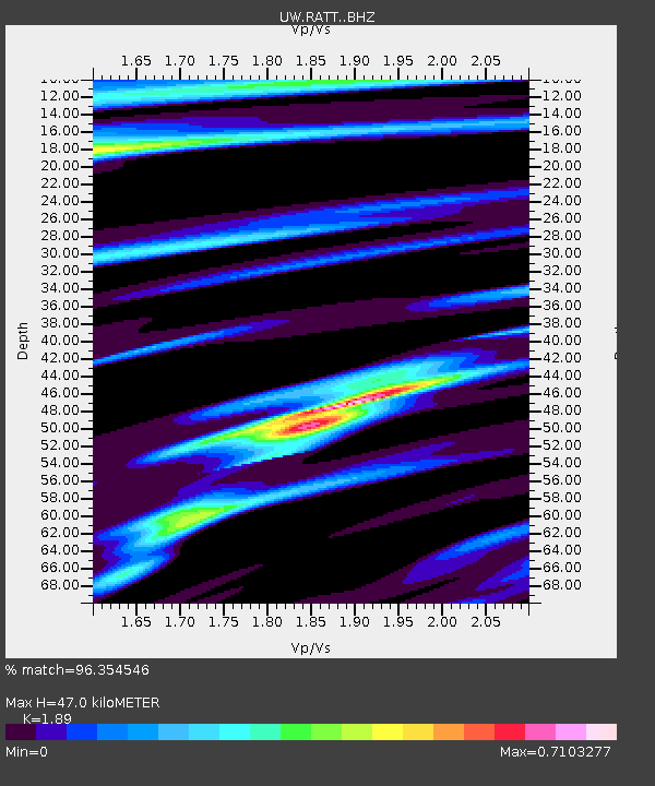
| Estimated Moho Depth: |
47.0 km |
| Estimated Crust Vp/Vs: |
1.89 |
| Assumed Crust Vp: |
6.597 km/s |
| Estimated Crust Vs: |
3.491 km/s |
| Estimated Crust Poisson's Ratio: |
0.31 |
|
| Radial Match: |
96.354546 % |
| Radial Bump: |
334 |
| Transverse Match: |
92.39147 % |
| Transverse Bump: |
400 |
| SOD ConfigId: |
11737051 |
| Insert Time: |
2019-04-26 03:14:16.271 +0000 |
| GWidth: |
2.5 |
| Max Bumps: |
400 |
| Tol: |
0.001 |
|

Signal To Noise
| Channel | StoN | STA | LTA |
| UW:RATT: :BHZ:20161121T21:10:14.765005Z | 6.9361587 | 1.4068015E-6 | 2.0282141E-7 |
| UW:RATT: :BHN:20161121T21:10:14.765005Z | 1.9124737 | 2.1303353E-7 | 1.11391614E-7 |
| UW:RATT: :BHE:20161121T21:10:14.765005Z | 2.8749332 | 5.488922E-7 | 1.9092346E-7 |
| Arrivals |
| Ps | 6.6 SECOND |
| PpPs | 20 SECOND |
| PsPs/PpSs | 26 SECOND |


