You are here: Home > Network List > X416 - Monitoring Active Faults for Tectonic Mapping Efforts in Washington State Stations List
> Station MA02 King County, WA, USA > Earthquake Result Viewer
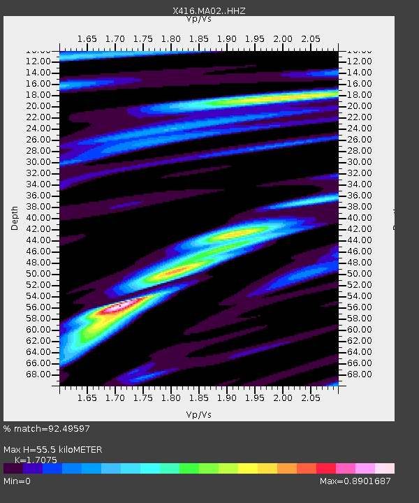
MA02 King County, WA, USA - Earthquake Result Viewer
| Earthquake location: |
Near East Coast Of Honshu, Japan |
| Earthquake latitude/longitude: |
37.4/141.4 |
| Earthquake time(UTC): |
2016/11/21 (326) 20:59:49 GMT |
| Earthquake Depth: |
11 km |
| Earthquake Magnitude: |
6.9 MWB, 7.3 MI |
| Earthquake Catalog/Contributor: |
NEIC PDE/NEIC COMCAT |
|
| Network: |
X4 Monitoring Active Faults for Tectonic Mapping Efforts in Washington State |
| Station: |
MA02 King County, WA, USA |
| Lat/Lon: |
47.72 N/121.83 W |
| Elevation: |
-1.0 m |
|
| Distance: |
67.5 deg |
| Az: |
46.529 deg |
| Baz: |
301.122 deg |
| Ray Param: |
0.056912277 |
| Estimated Moho Depth: |
55.5 km |
| Estimated Crust Vp/Vs: |
1.71 |
| Assumed Crust Vp: |
6.597 km/s |
| Estimated Crust Vs: |
3.864 km/s |
| Estimated Crust Poisson's Ratio: |
0.24 |
|
| Radial Match: |
92.49597 % |
| Radial Bump: |
400 |
| Transverse Match: |
82.334236 % |
| Transverse Bump: |
400 |
| SOD ConfigId: |
11737051 |
| Insert Time: |
2019-04-26 03:14:35.207 +0000 |
| GWidth: |
2.5 |
| Max Bumps: |
400 |
| Tol: |
0.001 |
|

Signal To Noise
| Channel | StoN | STA | LTA |
| X4:MA02: :HHZ:20161121T21:10:13.689993Z | 7.556306 | 1.3276234E-6 | 1.7569741E-7 |
| X4:MA02: :HHN:20161121T21:10:13.689993Z | 1.5874836 | 2.1289848E-7 | 1.3411068E-7 |
| X4:MA02: :HHE:20161121T21:10:13.689993Z | 4.5824356 | 7.158005E-7 | 1.5620526E-7 |
| Arrivals |
| Ps | 6.2 SECOND |
| PpPs | 22 SECOND |
| PsPs/PpSs | 28 SECOND |


