You are here: Home > Network List > YN10 - San Jacinto Fault Zone Stations List
> Station JORD JORD > Earthquake Result Viewer
JORD JORD - Earthquake Result Viewer
| Earthquake location: |
Near East Coast Of Honshu, Japan |
| Earthquake latitude/longitude: |
37.4/141.4 |
| Earthquake time(UTC): |
2016/11/21 (326) 20:59:49 GMT |
| Earthquake Depth: |
11 km |
| Earthquake Magnitude: |
6.9 MWB, 7.3 MI |
| Earthquake Catalog/Contributor: |
NEIC PDE/NEIC COMCAT |
|
| Network: |
YN San Jacinto Fault Zone |
| Station: |
JORD JORD |
| Lat/Lon: |
33.47 N/116.64 W |
| Elevation: |
1235 m |
|
| Distance: |
78.8 deg |
| Az: |
56.468 deg |
| Baz: |
307.411 deg |
| Ray Param: |
0.049387038 |
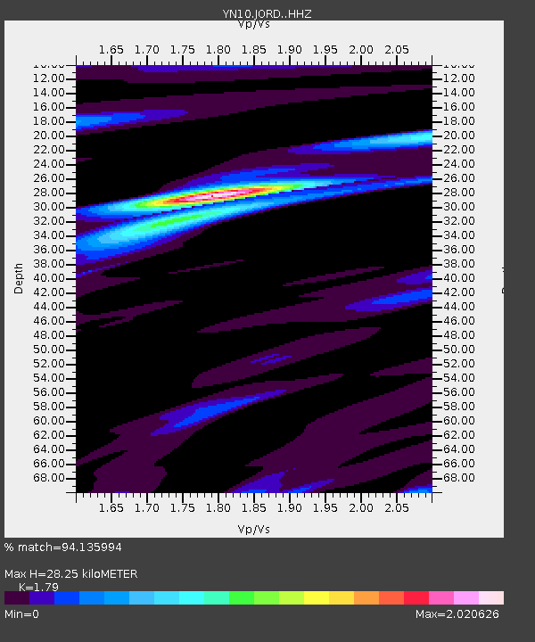
| Estimated Moho Depth: |
28.25 km |
| Estimated Crust Vp/Vs: |
1.79 |
| Assumed Crust Vp: |
6.264 km/s |
| Estimated Crust Vs: |
3.499 km/s |
| Estimated Crust Poisson's Ratio: |
0.27 |
|
| Radial Match: |
94.135994 % |
| Radial Bump: |
400 |
| Transverse Match: |
76.60426 % |
| Transverse Bump: |
400 |
| SOD ConfigId: |
11737051 |
| Insert Time: |
2019-04-26 03:15:20.656 +0000 |
| GWidth: |
2.5 |
| Max Bumps: |
400 |
| Tol: |
0.001 |
|

Signal To Noise
| Channel | StoN | STA | LTA |
| YN:JORD: :HHZ:20161121T21:11:20.333975Z | 3.2176213 | 1.0811784E-6 | 3.360179E-7 |
| YN:JORD: :HHN:20161121T21:11:20.333975Z | 1.3653487 | 4.422501E-7 | 3.2391E-7 |
| YN:JORD: :HHE:20161121T21:11:20.333975Z | 1.199371 | 2.6520706E-7 | 2.211218E-7 |
| Arrivals |
| Ps | 3.7 SECOND |
| PpPs | 12 SECOND |
| PsPs/PpSs | 16 SECOND |


