You are here: Home > Network List > BK - Berkeley Digital Seismograph Network Stations List
> Station SAO San Andreas Geophysical Obs., Hollister, CA, USA > Earthquake Result Viewer
SAO San Andreas Geophysical Obs., Hollister, CA, USA - Earthquake Result Viewer
| Earthquake location: |
Kermadec Islands Region |
| Earthquake latitude/longitude: |
-27.4/-176.3 |
| Earthquake time(UTC): |
2009/02/18 (049) 21:53:45 GMT |
| Earthquake Depth: |
25 km |
| Earthquake Magnitude: |
6.8 MB, 7.2 MS, 6.9 MW, 6.9 MW |
| Earthquake Catalog/Contributor: |
WHDF/NEIC |
|
| Network: |
BK Berkeley Digital Seismograph Network |
| Station: |
SAO San Andreas Geophysical Obs., Hollister, CA, USA |
| Lat/Lon: |
36.76 N/121.45 W |
| Elevation: |
317 m |
|
| Distance: |
82.1 deg |
| Az: |
41.542 deg |
| Baz: |
227.228 deg |
| Ray Param: |
0.04709951 |
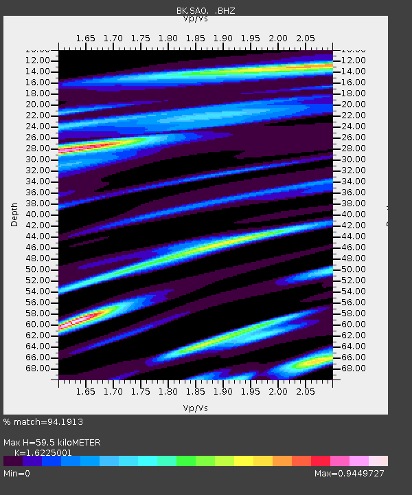
| Estimated Moho Depth: |
59.5 km |
| Estimated Crust Vp/Vs: |
1.62 |
| Assumed Crust Vp: |
6.391 km/s |
| Estimated Crust Vs: |
3.939 km/s |
| Estimated Crust Poisson's Ratio: |
0.19 |
|
| Radial Match: |
94.1913 % |
| Radial Bump: |
400 |
| Transverse Match: |
92.503136 % |
| Transverse Bump: |
353 |
| SOD ConfigId: |
2658 |
| Insert Time: |
2010-03-05 19:52:51.082 +0000 |
| GWidth: |
2.5 |
| Max Bumps: |
400 |
| Tol: |
0.001 |
|

Signal To Noise
| Channel | StoN | STA | LTA |
| BK:SAO: :BHZ:20090218T22:05:32.061001Z | 6.732033 | 3.4329103E-6 | 5.099367E-7 |
| BK:SAO: :BHN:20090218T22:05:32.061001Z | 1.0805587 | 6.906984E-7 | 6.392049E-7 |
| BK:SAO: :BHE:20090218T22:05:32.061001Z | 2.1117625 | 9.869577E-7 | 4.6736207E-7 |
| Arrivals |
| Ps | 6.0 SECOND |
| PpPs | 24 SECOND |
| PsPs/PpSs | 30 SECOND |


