You are here: Home > Network List > YR16 - Armatrice Sequence International Stations List
> Station ED12 CORTIGNO > Earthquake Result Viewer
ED12 CORTIGNO - Earthquake Result Viewer
| Earthquake location: |
Near East Coast Of Honshu, Japan |
| Earthquake latitude/longitude: |
37.4/141.4 |
| Earthquake time(UTC): |
2016/11/21 (326) 20:59:49 GMT |
| Earthquake Depth: |
11 km |
| Earthquake Magnitude: |
6.9 MWB, 7.3 MI |
| Earthquake Catalog/Contributor: |
NEIC PDE/NEIC COMCAT |
|
| Network: |
YR Armatrice Sequence International |
| Station: |
ED12 CORTIGNO |
| Lat/Lon: |
42.81 N/12.98 E |
| Elevation: |
1127 m |
|
| Distance: |
87.4 deg |
| Az: |
324.751 deg |
| Baz: |
38.653 deg |
| Ray Param: |
0.043340392 |
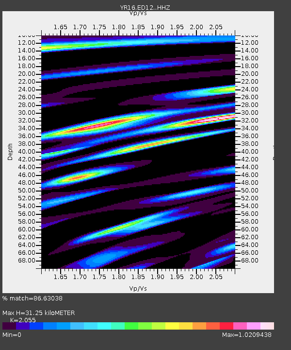
| Estimated Moho Depth: |
31.25 km |
| Estimated Crust Vp/Vs: |
2.06 |
| Assumed Crust Vp: |
6.276 km/s |
| Estimated Crust Vs: |
3.054 km/s |
| Estimated Crust Poisson's Ratio: |
0.34 |
|
| Radial Match: |
86.63038 % |
| Radial Bump: |
400 |
| Transverse Match: |
84.72852 % |
| Transverse Bump: |
400 |
| SOD ConfigId: |
11737051 |
| Insert Time: |
2019-04-26 03:15:36.647 +0000 |
| GWidth: |
2.5 |
| Max Bumps: |
400 |
| Tol: |
0.001 |
|

Signal To Noise
| Channel | StoN | STA | LTA |
| YR:ED12: :HHZ:20161121T21:12:04.619985Z | 3.4546134 | 5.2940084E-7 | 1.5324459E-7 |
| YR:ED12: :HHN:20161121T21:12:04.619985Z | 1.1792696 | 1.548941E-7 | 1.3134749E-7 |
| YR:ED12: :HHE:20161121T21:12:04.619985Z | 1.1781304 | 1.2142495E-7 | 1.03065794E-7 |
| Arrivals |
| Ps | 5.4 SECOND |
| PpPs | 15 SECOND |
| PsPs/PpSs | 20 SECOND |


