You are here: Home > Network List > YX16 - Raton Basin UNM Broadband Network Stations List
> Station UNM6 NE Corner of CO Stations > Earthquake Result Viewer
UNM6 NE Corner of CO Stations - Earthquake Result Viewer
| Earthquake location: |
Near East Coast Of Honshu, Japan |
| Earthquake latitude/longitude: |
37.4/141.4 |
| Earthquake time(UTC): |
2016/11/21 (326) 20:59:49 GMT |
| Earthquake Depth: |
11 km |
| Earthquake Magnitude: |
6.9 MWB, 7.3 MI |
| Earthquake Catalog/Contributor: |
NEIC PDE/NEIC COMCAT |
|
| Network: |
YX Raton Basin UNM Broadband Network |
| Station: |
UNM6 NE Corner of CO Stations |
| Lat/Lon: |
37.35 N/104.72 W |
| Elevation: |
2084 m |
|
| Distance: |
83.8 deg |
| Az: |
47.14 deg |
| Baz: |
312.892 deg |
| Ray Param: |
0.045945503 |
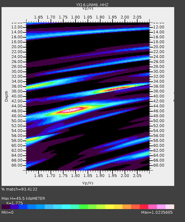
| Estimated Moho Depth: |
45.5 km |
| Estimated Crust Vp/Vs: |
1.77 |
| Assumed Crust Vp: |
6.316 km/s |
| Estimated Crust Vs: |
3.558 km/s |
| Estimated Crust Poisson's Ratio: |
0.27 |
|
| Radial Match: |
93.4132 % |
| Radial Bump: |
389 |
| Transverse Match: |
84.79576 % |
| Transverse Bump: |
400 |
| SOD ConfigId: |
11737051 |
| Insert Time: |
2019-04-26 03:15:45.728 +0000 |
| GWidth: |
2.5 |
| Max Bumps: |
400 |
| Tol: |
0.001 |
|

Signal To Noise
| Channel | StoN | STA | LTA |
| YX:UNM6: :HHZ:20161121T21:11:46.590017Z | 7.7576237 | 1.1855719E-6 | 1.5282669E-7 |
| YX:UNM6: :HHN:20161121T21:11:46.590017Z | 1.092101 | 2.6385075E-7 | 2.4159922E-7 |
| YX:UNM6: :HHE:20161121T21:11:46.590017Z | 2.071595 | 4.0517992E-7 | 1.955884E-7 |
| Arrivals |
| Ps | 5.7 SECOND |
| PpPs | 20 SECOND |
| PsPs/PpSs | 25 SECOND |


