You are here: Home > Network List > BK - Berkeley Digital Seismograph Network Stations List
> Station SAO San Andreas Geophysical Obs., Hollister, CA, USA > Earthquake Result Viewer
SAO San Andreas Geophysical Obs., Hollister, CA, USA - Earthquake Result Viewer

| Earthquake location: |
Santa Cruz Islands Region |
| Earthquake latitude/longitude: |
-11.0/164.5 |
| Earthquake time(UTC): |
2008/07/19 (201) 09:27:01 GMT |
| Earthquake Depth: |
11 km |
| Earthquake Magnitude: |
6.1 MB, 6.4 MS, 6.6 MW, 6.6 MW |
| Earthquake Catalog/Contributor: |
WHDF/NEIC |
|
| Network: |
BK Berkeley Digital Seismograph Network |
| Station: |
SAO San Andreas Geophysical Obs., Hollister, CA, USA |
| Lat/Lon: |
36.76 N/121.45 W |
| Elevation: |
317 m |
|
| Distance: |
84.1 deg |
| Az: |
50.922 deg |
| Baz: |
251.63 deg |
| Ray Param: |
0.04573038 |
| Estimated Moho Depth: |
12.75 km |
| Estimated Crust Vp/Vs: |
2.08 |
| Assumed Crust Vp: |
6.391 km/s |
| Estimated Crust Vs: |
3.072 km/s |
| Estimated Crust Poisson's Ratio: |
0.35 |
|
| Radial Match: |
86.92 % |
| Radial Bump: |
400 |
| Transverse Match: |
82.57824 % |
| Transverse Bump: |
400 |
| SOD ConfigId: |
2658 |
| Insert Time: |
2010-03-05 19:53:04.106 +0000 |
| GWidth: |
2.5 |
| Max Bumps: |
400 |
| Tol: |
0.001 |
|
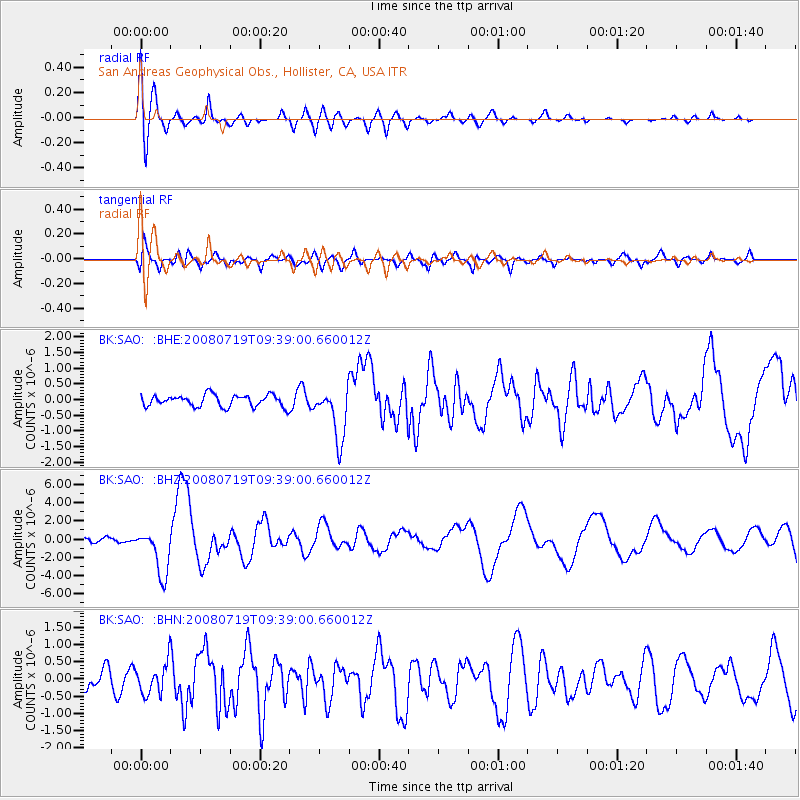
Signal To Noise
| Channel | StoN | STA | LTA |
| BK:SAO: :BHZ:20080719T09:39:00.660012Z | 12.273804 | 2.582776E-6 | 2.1042996E-7 |
| BK:SAO: :BHN:20080719T09:39:00.660012Z | 1.570232 | 4.434655E-7 | 2.8242036E-7 |
| BK:SAO: :BHE:20080719T09:39:00.660012Z | 4.4661913 | 8.385369E-7 | 1.8775212E-7 |
| Arrivals |
| Ps | 2.2 SECOND |
| PpPs | 6.0 SECOND |
| PsPs/PpSs | 8.2 SECOND |


