You are here: Home > Network List > BK - Berkeley Digital Seismograph Network Stations List
> Station SAO San Andreas Geophysical Obs., Hollister, CA, USA > Earthquake Result Viewer
SAO San Andreas Geophysical Obs., Hollister, CA, USA - Earthquake Result Viewer
| Earthquake location: |
Southeast Of Loyalty Islands |
| Earthquake latitude/longitude: |
-22.4/170.6 |
| Earthquake time(UTC): |
2009/01/15 (015) 07:27:20 GMT |
| Earthquake Depth: |
27 km |
| Earthquake Magnitude: |
5.8 MB, 6.5 MS, 6.7 MW, 6.6 MW |
| Earthquake Catalog/Contributor: |
WHDF/NEIC |
|
| Network: |
BK Berkeley Digital Seismograph Network |
| Station: |
SAO San Andreas Geophysical Obs., Hollister, CA, USA |
| Lat/Lon: |
36.76 N/121.45 W |
| Elevation: |
317 m |
|
| Distance: |
86.9 deg |
| Az: |
48.178 deg |
| Baz: |
239.217 deg |
| Ray Param: |
0.043686107 |
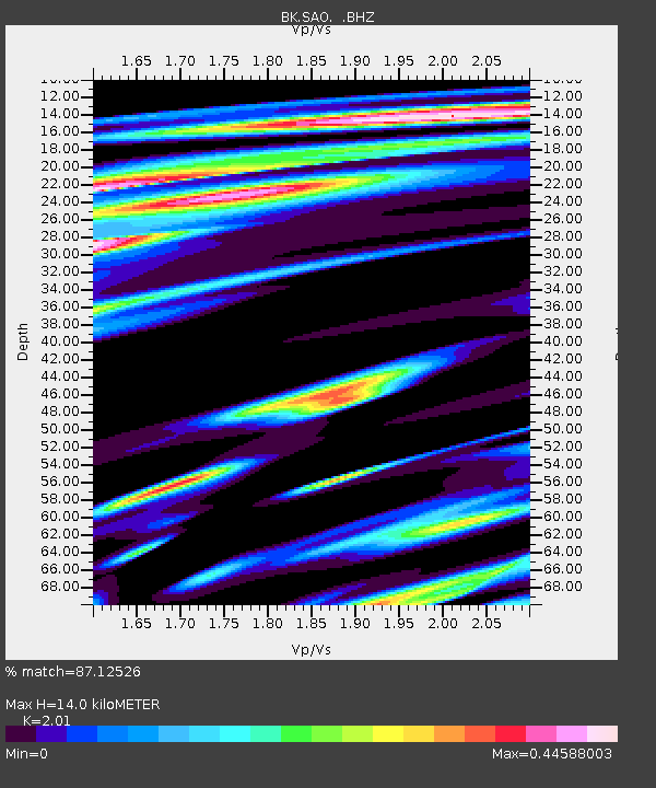
| Estimated Moho Depth: |
14.0 km |
| Estimated Crust Vp/Vs: |
2.01 |
| Assumed Crust Vp: |
6.391 km/s |
| Estimated Crust Vs: |
3.179 km/s |
| Estimated Crust Poisson's Ratio: |
0.34 |
|
| Radial Match: |
87.12526 % |
| Radial Bump: |
400 |
| Transverse Match: |
77.98056 % |
| Transverse Bump: |
400 |
| SOD ConfigId: |
2834 |
| Insert Time: |
2010-03-05 19:53:06.145 +0000 |
| GWidth: |
2.5 |
| Max Bumps: |
400 |
| Tol: |
0.001 |
|

Signal To Noise
| Channel | StoN | STA | LTA |
| BK:SAO: :BHZ:20090115T07:39:31.18502Z | 9.37578 | 1.6895895E-6 | 1.8020786E-7 |
| BK:SAO: :BHN:20090115T07:39:31.18502Z | 1.2083714 | 2.522171E-7 | 2.0872481E-7 |
| BK:SAO: :BHE:20090115T07:39:31.18502Z | 2.2355404 | 4.138E-7 | 1.8510065E-7 |
| Arrivals |
| Ps | 2.3 SECOND |
| PpPs | 6.5 SECOND |
| PsPs/PpSs | 8.7 SECOND |


