You are here: Home > Network List > BK - Berkeley Digital Seismograph Network Stations List
> Station SAO San Andreas Geophysical Obs., Hollister, CA, USA > Earthquake Result Viewer
SAO San Andreas Geophysical Obs., Hollister, CA, USA - Earthquake Result Viewer
| Earthquake location: |
Tonga Islands |
| Earthquake latitude/longitude: |
-20.8/-174.3 |
| Earthquake time(UTC): |
2009/07/30 (211) 20:05:34 GMT |
| Earthquake Depth: |
10 km |
| Earthquake Magnitude: |
5.9 MB, 5.7 MS, 5.8 MW, 5.7 MW |
| Earthquake Catalog/Contributor: |
WHDF/NEIC |
|
| Network: |
BK Berkeley Digital Seismograph Network |
| Station: |
SAO San Andreas Geophysical Obs., Hollister, CA, USA |
| Lat/Lon: |
36.76 N/121.45 W |
| Elevation: |
317 m |
|
| Distance: |
75.9 deg |
| Az: |
41.261 deg |
| Baz: |
230.186 deg |
| Ray Param: |
0.051340267 |
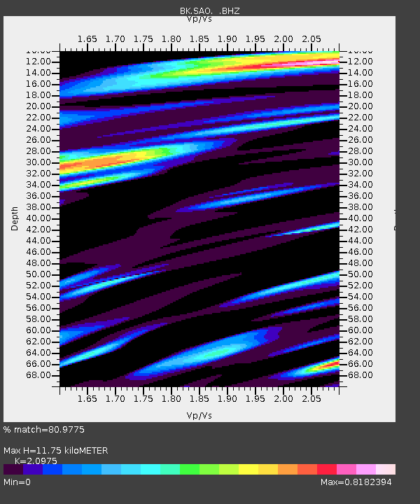
| Estimated Moho Depth: |
11.75 km |
| Estimated Crust Vp/Vs: |
2.10 |
| Assumed Crust Vp: |
6.391 km/s |
| Estimated Crust Vs: |
3.047 km/s |
| Estimated Crust Poisson's Ratio: |
0.35 |
|
| Radial Match: |
80.9775 % |
| Radial Bump: |
400 |
| Transverse Match: |
77.883064 % |
| Transverse Bump: |
383 |
| SOD ConfigId: |
2622 |
| Insert Time: |
2010-03-05 19:53:10.443 +0000 |
| GWidth: |
2.5 |
| Max Bumps: |
400 |
| Tol: |
0.001 |
|
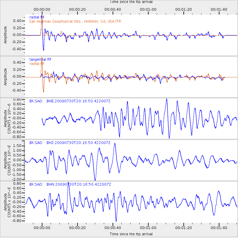
Signal To Noise
| Channel | StoN | STA | LTA |
| BK:SAO: :BHZ:20090730T20:16:50.422007Z | 4.7372985 | 5.925796E-7 | 1.2508809E-7 |
| BK:SAO: :BHN:20090730T20:16:50.422007Z | 1.8709909 | 2.4262462E-7 | 1.2967708E-7 |
| BK:SAO: :BHE:20090730T20:16:50.422007Z | 2.811392 | 2.7747078E-7 | 9.869515E-8 |
| Arrivals |
| Ps | 2.1 SECOND |
| PpPs | 5.5 SECOND |
| PsPs/PpSs | 7.6 SECOND |


