You are here: Home > Network List > YT07 - POLENET Stations List
> Station HOWE HOWE > Earthquake Result Viewer
HOWE HOWE - Earthquake Result Viewer
| Earthquake location: |
Off E. Coast Of N. Island, N.Z. |
| Earthquake latitude/longitude: |
-40.6/177.1 |
| Earthquake time(UTC): |
2016/11/22 (327) 00:19:42 GMT |
| Earthquake Depth: |
9.6 km |
| Earthquake Magnitude: |
5.9 MWW |
| Earthquake Catalog/Contributor: |
NEIC PDE/NEIC COMCAT |
|
| Network: |
YT POLENET |
| Station: |
HOWE HOWE |
| Lat/Lon: |
87.42 S/149.43 W |
| Elevation: |
2607 m |
|
| Distance: |
47.4 deg |
| Az: |
178.052 deg |
| Baz: |
325.224 deg |
| Ray Param: |
0.069984935 |
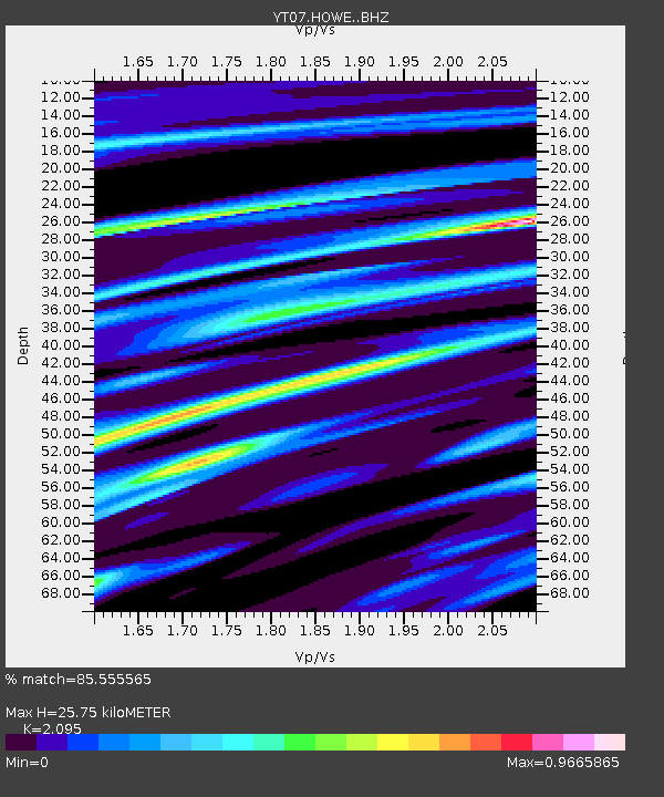
| Estimated Moho Depth: |
25.75 km |
| Estimated Crust Vp/Vs: |
2.10 |
| Assumed Crust Vp: |
6.182 km/s |
| Estimated Crust Vs: |
2.951 km/s |
| Estimated Crust Poisson's Ratio: |
0.35 |
|
| Radial Match: |
85.555565 % |
| Radial Bump: |
400 |
| Transverse Match: |
69.56572 % |
| Transverse Bump: |
400 |
| SOD ConfigId: |
11737051 |
| Insert Time: |
2019-04-26 03:20:18.355 +0000 |
| GWidth: |
2.5 |
| Max Bumps: |
400 |
| Tol: |
0.001 |
|

Signal To Noise
| Channel | StoN | STA | LTA |
| YT:HOWE: :BHZ:20161122T00:27:46.99899Z | 2.287439 | 2.8791172E-7 | 1.258664E-7 |
| YT:HOWE: :BHN:20161122T00:27:46.99899Z | 0.801847 | 8.740242E-8 | 1.0900137E-7 |
| YT:HOWE: :BHE:20161122T00:27:46.99899Z | 2.1948228 | 1.6469735E-7 | 7.503902E-8 |
| Arrivals |
| Ps | 4.8 SECOND |
| PpPs | 12 SECOND |
| PsPs/PpSs | 17 SECOND |


