You are here: Home > Network List > YT07 - POLENET Stations List
> Station UNGL UNGL > Earthquake Result Viewer
UNGL UNGL - Earthquake Result Viewer
| Earthquake location: |
Off E. Coast Of N. Island, N.Z. |
| Earthquake latitude/longitude: |
-40.6/177.1 |
| Earthquake time(UTC): |
2016/11/22 (327) 00:19:42 GMT |
| Earthquake Depth: |
9.6 km |
| Earthquake Magnitude: |
5.9 MWW |
| Earthquake Catalog/Contributor: |
NEIC PDE/NEIC COMCAT |
|
| Network: |
YT POLENET |
| Station: |
UNGL UNGL |
| Lat/Lon: |
79.77 S/82.52 W |
| Elevation: |
745 m |
|
| Distance: |
52.2 deg |
| Az: |
167.145 deg |
| Baz: |
251.481 deg |
| Ray Param: |
0.06692377 |
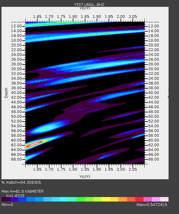
| Estimated Moho Depth: |
61.5 km |
| Estimated Crust Vp/Vs: |
1.63 |
| Assumed Crust Vp: |
6.182 km/s |
| Estimated Crust Vs: |
3.787 km/s |
| Estimated Crust Poisson's Ratio: |
0.20 |
|
| Radial Match: |
84.306305 % |
| Radial Bump: |
400 |
| Transverse Match: |
63.456966 % |
| Transverse Bump: |
400 |
| SOD ConfigId: |
11737051 |
| Insert Time: |
2019-04-26 03:20:38.571 +0000 |
| GWidth: |
2.5 |
| Max Bumps: |
400 |
| Tol: |
0.001 |
|

Signal To Noise
| Channel | StoN | STA | LTA |
| YT:UNGL: :BHZ:20161122T00:28:22.900022Z | 4.9058223 | 6.418493E-7 | 1.3083418E-7 |
| YT:UNGL: :BHN:20161122T00:28:22.900022Z | 1.5838304 | 1.7251514E-7 | 1.0892274E-7 |
| YT:UNGL: :BHE:20161122T00:28:22.900022Z | 3.4516006 | 3.549597E-7 | 1.0283916E-7 |
| Arrivals |
| Ps | 6.7 SECOND |
| PpPs | 25 SECOND |
| PsPs/PpSs | 31 SECOND |


